ARUNACHAL – THE LAND OF THE RISING SUN

Featured

Arunachal Pradesh, is the State where the first sun rays hit India. The North Eastern most State of India is surrounded by China and Myanmar to its East. The remoteness of the land and the terrain makes Arunachal resplendent with natural beauty. The Eastern Himalayas rolls over in never ending slices of lush, thick tropical evergreen and moist deciduous forests.

As part of a group of Naturalists – Madras Naturalists Society- (MNS) from Chennai, we visited the South Eastern part of Arunachal covering Namsai, Dong, Walong with Namdapha National Park and Maguri Beel, a wetland in Assam on the way.

The Google Map link to the entire trip is below:

https://maps.app.goo.gl/o9v78Y1KJXAE3jHB9

The MNS group has avid birders who grudgingly allow a bit of history and culture to be experienced. In that sense this trip was a well rounded one unlike the ones where it is generally craning of necks for birds and birds alone. The single minded focus on birds should be seen to be believed. Not to exaggerate, our driver Pappu glanced at something big and dark in the bushes along the road. He shouted “Bhaaloo, Bhaaloo”. Immediately doors of all cars flung open with everyone rushing towards the spot. On realising that it could be a bear, one of the participants called out her husband who was behind and asked him to stay put as it was just a bear and not any bird !. It ultimately turned out to be a large pheasant which disappeared.

Dibrugarh is the eastern most commercial airport in India from where one disembarks and takes the road to Arunachal. Our first stop was to a small town Namsai. There is a shimmering Golden Pagoda here with Thai architecture of the Theravada sect of Buddhism. Surrounded by well laid out gardens, it is a haven of peace with the glittering Buddha overseeing majestically. The Golden Pagoda Eco Resort just behind the temple, is a quiet and clean place to stay.

GOLDEN PAGODA TEMPLE

The next town in our schedule was Dong, a small, far-off place from Namsai near Walong on the eastern most border of India after which one enters Chinese territory. The long road trip from Namsai to Dong, gave us a chance to not only appreciate the landscape but also have a glimpse of the locals.

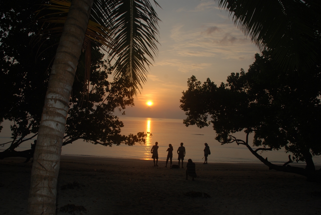
The Dong Resort is a decent place to stay near the hot springs by the side of River Lohit. The river was our constant companion along the road from Namsai and meanders through in different hues. It is a tributary of the mighty Brahmaputra and originates in Tibet.

LOHIT RIVER IN ALL ITS HUES AND MOODS

We noticed a Jal Jeevan mission painting on the compound wall of the resort which read ” You can survive with love but not without water”, a message to convey the importance of water and its conservation. We realised the import of this when we were literally caught with our pants down in the washrooms. Water and electricity are rare commodities in these outlying areas and one needs to be ready with alternatives and standbys, including tissues, torches, spare batteries etc. The Dong resort was in itself a place for moths and butterflies. We saw a fascinating big Owl Moth here.

OWL MOTH

In all border areas, whether at Ladakh or at Arunachal, one common sight is the signposts of BRO ( Border Roads Organisation) which constructs roads and bridges to facilitate the smooth movement of armed forces and artillery. Hectic road cutting activity was happening on our way to the last village ( or the first village as our PM says) of Kaho. The Chinese are hardly a km away, as the crow flies.

There is naturally a strong presence of the army on the ridges with bunkers pockmarked on the sides of the mountains. There were some breathtaking waterfalls and enchanting landscapes along the way. The viewpoint gazebo is at a vantage spot overlooking the valley. Busily photographing the birds and the scenery, I ignored mosquito bites on the way back only to realise the next morning that both the back of the palms had “fried Kerala pappad” swells due to some insect bite. A bit of irritation but no pain and a good doctor in the group whipped up a tablet to arrest the swelling.

It was a memorable road trip to Helmet Top the next morning. The place is named as a remembrance to the many gallant soldiers who perished in the biting cold with little to cover and nothing to eat and yet managed to keep at bay, for a while, the advancing Chinese troops in 1962.

Our driver Pappu informed us that when he went out the previous evening to get a can of diesel for the car, he had met a Tamilian sentry at the check-post leading to Helmet Top who was keen on meeting our group as he was told that we were predominantly Tamil speaking. We were greeted with a beaming smile by the Jawan from Tirunelveli at the entry to Helmet Top. He was visibly excited on seeing us and started to straightaway converse in Tamil. He was yearning to speak with some one in his mother tongue. Not to be left behind, there was another soldier who moved quickly from one car to the other looking for Telugu speakers in our group. Luckily, apart from me who speaks a smattering of Telugu, there was a couple from Andhra and we could see the smile on the face of ‘mana vaadu.’ The Tamil jawan informed us in Tamil that his previous posting was in Ladakh!. The battle hardened army men have a melting inner core and their joy knows no bounds on seeing some humans, other than the uniformed, after long spells of being cut out from the outside world. Tears rolled in my eyes when Pappu later told me that the Jawan had worked the previous night and was waiting at the check post without going back just to speak with us. The least we could do was to spend time with them and laud their supreme efforts in guarding us. I wish I could have taken some snaps with them but alas… security is more important.

Birding along the Helmet Top road, with practically no disturbance except the odd army vehicle ( it is out of bounds and needs permit), we were able to see a lot of birds and savour fabulous landscapes of wild grass, glistening ice-peaks and green mountain faces, a real treat to the urban eyes tired of seeing concrete jungles.

FIRST LIGHT FILTERING THROUGH SOFTLY

Once at the Helmet Top, we saw the small memorial built for the fallen soldiers. Some of the spent shells are kept as a lasting memory to the martyrs. The plaque’s etchings have worn away and reading it was difficult. It is reproduced below:

” IN THE MEMORY OF

Lt. BIKRAM SINGH & THE SOLDIERS OF DELTA COMPANY OF 6 KUMAON

THE BATTLE OF WALONG ON 16 th , NOVEMBER, 1962

Lt. Bikram Singh was holding a vital feature (.2817 at West Ridge) dominating
ALG & BDE HQ Walong. After an intense battle, approximately 300 Chinese
soldiers broke through and surrounded the defenses from three sides, the fourth
side being a cliff. Lt. Bikram Singh was to hold the defense till 11hrs on 16th
November, 1962. Under his courageous and gallant leadership the men fought
to finish well beyond 11 hrs. The Kumaonis fought until all their ammunition
was exhausted and they were completely overrun. The bulk of the Kumaonis
were either wounded or killed on the West Ridge. Bikram’s message to me over
the wireless was that he would hold on and would not withdraw. He fulfilled
these words to the limit.

By Brig. N.C. Rawlley MC ( DO NO A/P/13 dated 24 th December, 1962

The bodies of gallant soldiers of Delta Company of 6 Kumaon were discovered
on the West Ridge in the year 1986 by 6 Assam Regiment. The ashes of these
brave hearts continue to guard the nation from the West Ridge on your left. The
helmets of some of those brave hearts lay beside you as a testimony of their
courage and sacrifice.

The Western Ridge was also clearly visible( above), where all the casualties happened at the Helmet Top. We chatted with the regiment which comprised young jawans from all across the country – Jharkand, Bengal, Odisha …. Their hospitality of giving us hot Chai in the cold weather, without any expectations, was touching. Collectively, we looked sheepish and vowed that we should in future carry some sweets along for distributing to these generous souls, damn the airlines which might charge for overweight luggage.

While at Helmet Top, we were fortunate to spot the Yunnan Nuthatch, an important bird species endemic to this region. Unlike divisive humans, birds are free spirited and fly across from the Yunnan province of China. Kunming is just a few hundred kilometres as the crow flies.

We visited a bigger war memorial erected at Walong along the banks of Lohit on a hillock. There were huge statues of the Kumaoni Regiment soldiers with inscriptions describing the Battle of Walong and a list of the Gallantry Award winners in the 1962 war with the Chinese.

WALONG WAR MEMORIAL

While at Walong we saw the plains of Namsi, the battlefield of the Indo-Chinese war in 1962. Having breached Kibuthu, the Chinese intruded into Namsi. The Indian troops were ill-equipped and were famished without any replenishments of food, armaments or clothing when they had to defend. In those days, there was no road after Tezu, about 230 kms south-west of Namsi. Despite the odds, the bravehearts held their own for 22 days and saved Tezu from being captured by the Chinese.

PLAINS OF NAMSI INDO-CHINA 1962 WAR THEATRE

The next morning was spent in birding along the suspension bridge across Lohit river near the Dong resort. The hot spring near the bridge along Lohit was letting out misty steam every now and then.

On our way back to Namsai after our morning walk at Dong, we visited the holy Parasuram temple and the Kund. It is believed that Parasuram was wandering the Himalayas to cleanse himself of the sin of matricide and the axe in his hand fell leaving a fissure in the mountains and sprang a Brahmakund. The Parasuram Kund Mela which happens on Sankranti had just got over and the place wore a festive look. River Lohit flows by the temple and the Kund is along the banks where devotees take a holy dip. We reached the Golden Pagoda Eco Resort in the evening, ready for the next day morning visit to Namdapha National Park.

The morning saw a bit of rains and the Eco hotel campus was rich in birdlife. The highlight was the sighting of an Asian Barred Owlet at eye level posing innocently, yet probingly, in dripping water.

We proceeded to Miao, a small town which is one of the entry points for the Namdapha National Park and along the highway from Namsai, saw a lot of locals dressed in traditional attire for Bihu, the harvest festival of the Assamese/ NE just like Pongal in the South.

GIRLS IN TRADITIONAL DRESS FOR BIHU HARVEST FESTIVAL CELEBRATIONS

Namdapha NP ( derived from two words, ‘Nam’, water, in the local Singpho language and ‘Dapha’, the snow peak inside the Park) is a vast expanse of 1,985 sq kms. We reached Miao before sun down ( it turns dark by 5 pm during winters, being in the eastern part of India) and stayed at the Namdapha Jungle Camp, an eco resort built with local materials on stilts amidst picturesque surroundings. We went on a trek through wild grass to the Noa Dihing river flowing by. The river bed had stones and pebbles which had trundled down the mountains in different sizes, shapes and hues. We sighted some river birds and raptors by the riverside.

The next day took us through Namdapha NP to the Deban section of the Park. We had some stunning views of the evergreen forest, dense and deep. Namdapha is home to about 600 species of birds, some endemic and about 100 mammals. Blue Throated Barbets, Asian Blue Fairytails and woodpeckers were the highlight. We also saw the Wreathed Hornbill at a distance, endemic to Namdapha. There were also lots of Bulbuls, minivets, starlings along the way. We checked into the Forest Department’s guest house. It is set along the banks of the river Noa Dihing at an elevation, providing fascinating vistas of the grasslands, the river and the mountain ranges beyond. It was intriguing to watch a Malayan Giant Squirrel near the guest house looking inquisitively at us and jumping trees with gay abandon.      

ASIAN BLUE FAIRY TAIL (F&M) YELLOW NAPED WOODPECKER    SULTAN TIT

MALAYAN GIANT SQUIRREL JUMPING TREES

We took a night walk around the Forest guest house and spotted through torchlights the bright eyes of the Giant Flying Squirrel munching leaves merrily and jumping around. There was also a Collared Scops owl along the trail.

GIANT FLYING SQUIRREL

The next morning took us on an adventurous and exhilarating trek into the core of the Namdapha NP. Going down from the guest house, we passed through high grasslands, some taller than us and treaded with caution the river bed strewn with rough stones. The next challenge was to go across the Noa Dihing river. The initial plan was to cross by boats but the daring group quickly abandoned the idea and opted for crossing by foot on the rickety, makeshift bamboo bridge with intermittent big rocks kept on the sides as ballasts to withstand the currents of the river. It was a sight to see everyone balancing precariously with fear while crossing the 100 odd metres, banishing any thoughts of watching the beautiful landscape around. The last part of the obstacle race was to climb up a makeshift bamboo stairway with about 35 steep steps. At the end of it all we reached a watchtower which gave us a panoramic all round view of the landscape before starting our trek through the core area of the Park.

The thickly wooded forest with huge trees forming an impregnable canopy, the bamboo thickets bending to give a welcome arch and the ferns and lichens with many wild plants and fruits added colour to the walk.

The giant trees, spiderwebs, myriad birds, rich colours of butterflies and moths made the burden of trekking the ups and downs look like a walk in the park. We spotted a lot of birds, especially the majestic Rufous necked hornbill, both male and female perched and heard their occasional woosh, in the silence of the woods, flying across. In the end, we never realised we had walked for five hours and almost covered 10 kms deep inside the forest. If we had continued for another five days, we would have been on the Myanmar border town of Vijayanagar.

RUFOUS NECKED HORNBILL

There were colourful butterflies and moths too. It was not the best time of the year to spot butterflies and yet we were able to see plenty.

L-R: COMMON TIT, INDIAN TORTOISE SHELL, YELLOW ORANGE TIP, COMMON IMPERIAL, TABBY, LEOPARD LACEWING & CRUISER WITH A SPIDER WEB

The next morning was spent by a short trek around the fringes and were delighted to see the long-tailed broadbill, replete with a rash of bright colours, the ever-charming minivets in their spendour and the stylish black beauty – the greater racket tailed drongo showing off its wavy long tail and crisp crest. The blue-throated barbet posing in gentle sunlight in the open presented all its colours in fully glory – one never ceases to marvel at God’s creation of these rich- in- colour birds.

L-R : LONG TAILED BROADBILL, MINIVET, COMMON KINGFISHER AND GREATER RACKET TAILED DRONGO

BLUE THROATED BARBET

We rounded off the Namdapha leg by visiting the nearby Chakma village of Mpen II. Apparently, there is a Mpen I village too. Chakmas, followers of Theravada Buddhism and originally from Bangladesh, had the misfortune of being driven out of their country due to religious persecution. They are scattered throughout the North Eastern States. The Chakmas of Namdapha are the beneficiaries of the good natured local tribe of Singhpo who had graciously given up some land parcels to enable them lead a life of dignity.

Our group has always travelled to the North East through Help Tourism, a responsible tourist operator which promotes sustainable development and conservation in the areas it operates. Mr Asit Biswas the founder was waiting for us at the Nalanda Nature school for the Chakma kids. It was a delight to watch the tiny ones dancing for us in their traditional dress and savour the tasty lunch with the community.

The Chakmas are largely Stateless like the Sri Lankan Tamil refugees in India, falling between two stools, in a manner of speaking. Efforts are on to integrate them officially into the Indian society and bestow voting rights. We noted that the Chakmas had a script similar to the Burmese script and just one person in the village had the ability to write and pass on the legacy to the next generation. Mr Biswas is actively involved in preserving the script for posterity by recording. The school is for primary studies. The students, after the 5th grade have to walk or pedal nearly 13 kms to Miao for their middle/high school studies. Medicare is non-existent.

Just as the giant trees showed a mirror to our insignificance in the larger scheme of things, these children reminded us of how privileged and blessed we were. The group vowed to get back and contribute in more meaningful ways, both in terms of time and resources.

After the Chakma village visit, we headed to the Namdapha Jungle Lodge at Miao, about 15 kms away to stay the night before our departure the next day.

Maguri Beel is a wetland near Dibrugarh in Assam and enroute the airport. We decided to take a detour to this place and see the migrant waders in full force. We were certainly not disappointed with our sightings in the vast expanse of water, traversed through traditional wooden canoes at a gentle pace, giving enough time to absorb the landscape and the ducks in flight and on water. It was a treat to watch the different shades of the Northern lapwing and the bronze tailed Jacanas in particular. The migrant Bar headed geese which flies high over the Himalayas at 24,000 feet non-stop from as far away as Mongolia was a sight to behold.

L-R: PIN TAILED SNIPE, PIED KINGFISHER, BAR HEADED GEESE & RUDDY SHELLDUCKS, BARN SWALLOWS, CITRINE WAGTAIL, PHEASANT TAILED JACANAS, NORTHERN LAPWING, COMMON MOORE HEN & BRONZE WINGED JACANA IN FLT.

The nagging rankle at the end of every such trip to be with Nature in remote border areas is ” for how long will these places retain their pristinity”?. National security and infrastructural developments seem to be the twin necessary (d)evils that denude Nature and affect all the endemic species in these well protected areas.

One fervently hopes that “Aruna”, the sun, shines forever unpolluted in this “Aanchal”, the pretty North Eastern State in the corner of India.

MAHABALIPURAM STONECRAFT

Nearness leads to disenchantment. It is true in the case of many things including visiting historical places of importance close to you. The common refrain is – it is always there to see- a sure recipe for postponing. How many of us have taken time out to see important museums or monuments in the city we live. These are generally meant for excursions during school days and the only memories of such places would be the pranks on the bus ride or the ice-cream you had. Mahabalipuram, Mamallapuram or Mahabs for youngsters zipping past on bikes is popular for its beach. It is unlikely that many grown-ups and children alike in Chennai would have seen the architectural masterpieces of Mamallapuram in detail. Yet, it is a UNESCO World Heritage Site, just about 60 kms and an hour’s drive south of Chennai on the scenic East Coast Road running parallel to the sandy beaches of the beautiful Bay of Bengal. The recent World Chess Championships has shone the light on this remarkable place.

There were four main kingdoms in South IndiaCheras of present day Kerala, Pallavas with their capital at Kancheepuram, Cholas with capital at Thanjavur and Pandyas at Madurai.

In terms of architecture, Pallavas were the very first to experiment with hard granite, a medium not easy to work on. They pioneered cave temple architecture with open air bas relief and monolith works during the seventh-ninth centuries. The Pallava king Narasimhavarman is mainly credited for the architectural marvels of Mamallapuram.

At first sight, one wonders whether it was some sort of an open-air art studio where several experiments on a gigantic scale were in progress. Sculptures, with varying stages of completion lend credence to this belief.

The sites to visit are spread over a large area that would confuse the uninitiated with sequencing and time management. It is best to go with a good guide (which looked difficult) as otherwise one would be unable to appreciate the finer aspects of the architecture. I was fortunate to be in a group which was taken by Tamil Heritage Trust. They are committed to the cause of propagating the history and architecture of Mamallapuram with professional guides, well trained, including in epigraphy.

The heritage site, maintained by Archeological Survey of India (ASI), opens quite early at 6 a.m. which is the best time to visit as one can avoid the crowd and the harsh sun, approaching noon. The added advantage is to view the sun rise. The ticket counter houses a good collection of ASI’s booklets on various UNESCO Heritage Sites of India. The first stop was at the Five Rathas.

LOCATION MAP OF PANCHARATHAS

The Panchapandava Rathas (Chariots) are a classic example of an open-air craftsmen village where different forms of  single-stone carvings (monoliths) have been crafted by the Pallavas. The five Rathas have been carved out of hillocks and the form and styles are distinct. The Draupadi Ratha which is the first to the left as one enters has a hut type of roof, devoid of vimana. With Dwarapalakas (sentries) on either side, goddess Durga resides inside the sanctum.


The striking feature is a devotee in sitting posture with a sword, seen above, cutting the neck in an act of extreme self-sacrifice.     

The next ratha is the Arjuna ratha. The roof is square, followed by a pyramid and an octagonal top.  The deity inside is missing. The walls have some fine sculptures of Indra atop an elephant (also interpreted as Kartikeya). To the right of Indra are two beautiful ladies and to the left is a rishi with his faithful disciple as seen below.

SHIVA LEANING ON BULL

The south wall depicts Shiva languidly resting on His vehicle, the bull. There are two exquisitely carved royal couples on either side with head gears and finery.

Arjuna Ratha is followed by Bhima Ratha with a wagon roof, completely different from the first two. Here again, the deity inside is unknown. The mythical lion or vyalas are found on the pillars here. There are five arches on the roof.

BHIMA RATHA

The southern most ratha which is the largest is the Dharmaraja Ratha. This temple has inscriptions and is considered to be the model on which later temples of South India were constructed. The temple is three-tiered. The top tiers are complete but the lower one is incomplete. The staircase is available from the second to the third tier, but is not completed from first to the second.

DHARMARAJA RATHA

The side walls are adorned by Shiva, Brahma and Vishnu as also the Ardhanareeswarar brilliantly portrayed with subtle differences bringing out the masculine and feminine features.

ARDHANAREESWARAR
SIDE VIEW OF DHARMARAJA RATHA

The Nakula and Sahadeva Ratha below is to the side of Arjuna Ratha and the roof is again of a different style, that of apsidal or U-shaped. The varying roof types of the five rathas speak volumes of the experimentation conducted by the Pallavas. As if to reinforce the style, there is a huge monolithic elephant, which one can say is the mascot of Mamallapuram, with its back exactly resembling the roof of the Nakula and Sahadeva Ratha. This shows the inspiration the sculptors took from all living forms.

NAKULA AND SAHADEVA RATHA ALONGSIDE BACK OF ELEPHANT
MONOLITHIC ELEPHANT, MASCOT OF MAMALLAPURAM

After a good look at the rock cut sculptures and monoliths, it is time to head to the awe inspiring open air bas relief of Arjuna’s Penance. It is a wide angle canvas on a sheer rock face where the craftsmen have chiseled, end to end, a kaleidoscope of characters from the puranas. The 3D effect, with images popping up is mesmeric. The wide panel is more than 30 metres (100 ft) long and 12 metres (40 ft) high, an incredible size for an art canvas by any standards.

ARJUNA’S PENANCE PHOTO CREDIT: P. RAJESH

Ancient Indian history is always subject to interpretation as there are no written records. The mega open air Arjuna’s penance as it is popularly referred to is also interpreted as Bhagiratha’s penance. The central character is an emaciated person with exposed rib cages standing on one leg in extreme tapas. If it were to be taken as Arjuna, then his penance was to get the Pasupata astra from Lord Shiva to vanquish the Kauravas. If it were to be Bhagiratha, then his severe tapas was to propitiate Brahma and erase the curse to his forefathers by bringing down Ganga to the earth. Lord Shiva, larger than the tapasvi, is seen to the left, granting the boon.

The panel abounds with scenes like brahmins taking bath and a shrine of Vishnu with an ascetic bent in deep meditation. One can also see celestial beings like Gandharvas, Siddhas and Kinnaras floating. Sceneries of forest with wild animals abound. The cleft in between the rocks is where Ganga appears to descend with Nagas.

PHOTO CREDIT: P. RAJESH

The majestic elephant of 15 feet with its herd in attendance is a masterpiece. The hypocritical cat to the left of the elephant is also a classic. The cunning cat pretends to mimic the ascetics on one leg, lulls the mice to surround it and even pray at his feet ! The detailing in this wide open-air canvas would take at least half an hour to appreciate in full.

Adjacent to the gigantic open air bas relief of Arjuna’s penance is the Govardhana Mandapam which depicts the story of Lord Krishna through exquisite sculpting.

KRISHNA LIFTING GOVARDHANA MOUNTAIN

The panel above shows Krishna effortlessly lifting the Govardhana mountain with his left hand and saving the pastoral community from the fury of Nature induced by Indra. Balarama, brother of Krishna is to his right with his arm around a commoner who is seen squirming with folded hands. The pastoral scene is well captured below with one milking the cow and a lady carrying milk produce in her hands.

LADY MESMERISED BY KRISHNA’S FLUTE

The sculpture above is again a gem with Krishna playing melodious music on his flute and a lady totally lost in a trance, unmindful of the child dropping off her hip.

The east facing Shore Temple below is by the beach of Mamallapuram and largely eroded by the salty air. The temple was buried in sand and excavated by a Britisher Colin Mackenzie. The well maintained lawns of ASI and the blue sky and waters make the temple a fascinating sight.

The Sanctum of the Eastern temple is Shiva which is broken but there is a beautiful sculpture of Somaskandan where one can see Shiva and Parvathi along with son Skanda in between. There is a mini shrine for Lord Shiva by the side of the main temple.

The Lion temple below is a huge monolith of a lion with a scooped up square with Goddess Durga residing within.

LION TEMPLE WITH GODDESS DURGA INSET

The Shore Temple complex has a temple with reclining Vishnu known as Jalasayana Perumal, the lord residing by the water, which is under lock and one has to peer through a grilled door.

JALASAYANA PERUMAL

There are a number of cave shrines dotting Mamallapuram and prominent among them is the Mahishasura Mardini Mandapam, carved out of a hill.

The Mahishasura Mardini panel is probably the best of the sculptures in terms of poetry in motion with fine detailing. It is bewitching to see the calm, yet confident countenance of the Goddess riding a fierce lion in forward motion as also the fear in the demon’s eye, cowering and retreating in utter despair. One can also almost hear the twang of the bow as Goddess Durga vanquishes the demon. The fluidity of war is brilliantly brought out with great finesse.

DURGA ATOP LION VANQUISHING MAHISHASURA
RETREAT OF MAHISHASURA
ANANTASAYANA PERUMAL

Opposite the Durga panel is the Anantasayana Vishnu. Exquisitely carved with the Lord’s head resting on the five-headed hood of a serpent, He is in a deep, peaceful sleep. At the feet of Mahavishnu is Bhudevi. The indentations in the sculpture stand out splendidly.

Amidst several cave excavations, yet another exceptional one is that of the Varaha Mandapanam. Vishnu, in this avatara takes the form of a wild boar and rescues Bhudevi from a deluge. He delicately holds Her in His lower hand with a foot on top of the hood of a serpent. The ecstasy in Devi’s face is well depicted as is the tenderness with which she is handled.

VARAHA WITH BHOODEVI ON THIGH

The Varaha Mandapam also has the beautiful Gajalakshmi panel. The Goddess Lakshmi is sitting on a lotus throne with the protrusion brought out brilliantly. The elephants take turns in pouring holy water over Her and the attendants are ready with the water jugs.

GAJALAKSHMI

One more side of the Varaha Mandapa has this well chiselled, clearly defined Trivikrama below. Vishnu, in this avatar, also known as Vamana avathar, took the form of a dwarf to vanquish Mahabali by asking for a small piece of land to be measured in three steps. The arrogant Mahabali gave away the land derisively and found to his chagrin that the dwarf assumed gigantic proportions and after measuring the earth, lifts up his leg to reach for the heavens which is so clearly depicted in the sculpture below. The third step is on Mahabali’s head which can be seen. The celestial bodies surrounding the Lord in awe is brought out distinctively.

VAMANA

The Varaha Mandapam also houses Durga in standing position with a parasol above. With four dwarfs surrounding and two devotees sitting, one of them can be seen having a sword on the right hand and grasping the hair with the left in an act of suicide which was seen earlier in the Draupati ratha in the Panchapandava enclosure. This seems to be a ritual practiced in those days.

DURGA

The Olakkaneswara temple below is on a hillock which is the highest point of Mamallapuram and from where one can have a bird’s eye view of the Shore Temple. The British used this as a light house unmindful of its significance till a new one was built around 1900. It is actually Uzhakku-ennai ( a measure of oil) – Isvara temple which used to be collected for lighting a permanent lamp atop and which has morphed into Olakkaneswara temple.

OLAKKANESWARA TEMPLE

There is more to Mamallapuram, one of which is known as the Butter Ball which is a natural phenomenon where a huge boulder is precariously poised and a favourite spot for visitors to take selfies and photos, Atlas style.

BUTTER BALL

A few kilometers enroute Mamallapuram from Chennai is the tiger caves. Calling them tiger caves is a misnomer as it is actually the mythical lion known as Vyala. This open air amphitheatre must have been a place for dance or a resting place for the kings.

TIGER CAVES

Mamallapuram is dotted with many more wonderful mandapas with sculptures like the Ganesha Ratha, Adi Varaha Mandapam etc.

It is mind blowing to imagine such works of art about 1,400 years ago which has stood the test of time and ravages of Nature, including tsunamis. It must be on the “to-see” list of every resident of Chennai in particular and Indians in general. Foreigners seem to be more aware of our treasures than us, which is a pity.

Mahab is fab!

TALE OF TAILS AND STRIPES

Pench, situated in the heart of India at Madhya Pradesh is a vast tiger reserve with a portion falling in Maharashtra and managed by them. Just about 100 kms north of Nagpur in Maharashtra it is easily accessible through a smooth national highway. The River Pench flows through the park. Mowgli, the real life famous wolf boy at Seoni village in Pench formed the backdrop of The Jungle Book by Rudyard Kipling. Most children in India will remember the popular jingle of Mowgli serial in TV. Pench is also where the famous tigress Collarwali, which passed away recently birthed a number of cubs and lorded over the area royally. The total area is about 1,000 sq kms out of which 40% is core area.

The terrain is undulating with the Satpura hill range slopes. With the Pench river providing adequate water resources, it presents a perfect setting for wildlife, especially the tigers to thrive. The forest abounds with teak, Tendu, Mahua and Bael or wood apple trees providing enough flowers, leaves and fruits for the monkeys, deer and a host of birds.

Accommodation suiting a range of budgets is available. I was part of a group of naturalists and wildlife enthusiasts who stayed at Tiger N Woods resort last week. Easy on the pocket and set amidst a forested area on the periphery of the park with wooden Machans it was close to the Turia gate from which one had to enter the sanctuary core area.

SERENE REFLECTION

The best time to spot tigers, though not ideal given the scorching heat of Central India, is peak summer when all the big cats come out of hiding to slake their thirst in waterholes. Given the favourable odds, we had booked nine safaris in all – both early mornings and evenings- in open Maruti Gyspy jeeps. One had to jump like a scalded cat on coming in contact with the hand rails of the jeep in the afternoon safaris. With mercury in the mid 40 degrees centigrade, afternoon outings were hell on earth. As it goes, no pain, no gain.

The group had 28 members and 24 of them were treated with a number of sightings of tigers and tigresses with cubs as well as leopard darshans. Four of us in one jeep had the distinction of just seeing some vague stripes under a rock about a kilometre away on one occasion and the underbelly and a portion of a tiger tail on another.

I had written to my other friends who were at the same time freaking out at Tadoba Tiger reserve in Maharashtra that I planned to get back home and piece together the parts of the tigers seen and photoshop a full one, just to have bragging rights!. Even as we were giving up hopes on seeing a full tiger, maybe on the sixth safari, we viewed a sub-adult tigress lazing under the shade hidden from plain sight with tall grass, shrubs and twigs. There was a collective sigh whenever she moved her tail and just once did she get up momentarily to give a Papal like audience, resulting in some frenzied shrieks and crackle of camera clicks. Getting back to sleep the other way, no more chances were given despite all of us crowding for more than an hour in the scorching sun. At last, the sub-adult saved my back room processing!. That’s all about tigers.

LAZY TIGRESS UP
TIGRESS SETTLING DOWN TO SLEEP

The trigger happy finger mostly produced blurred images of grass and thickets with just two out of a few hundred snaps resulting in some view of the majestic cat.

The hard core naturalists that the foursome of us were, we just brushed aside the lack of tiger sightings as non-events and savoured the rich diversity of the landscape. At least that is the picture we had to present, vicariously enjoying the tiger and leopard sightings of others.

The usual suspects on the edges of the core zone were there in plenty like langurs at their pranking best and peacocks in full flow, shimmering and cavorting. Summer is the mating season for spotted deer and peacocks.

LANGUR WITH BABY
FRIENDS HUGGING

The loving kiss and warm embrace of the langurs was touching.

PEACOCK DANCE
PEACOCK IN FULL FLOW

The brilliant colours of the Jungle Fowl and the Painted Spur Fowl added sparkle to the place.

JUNGLE FOWL IN COLOURFUL PLUMAGE

It was soon clear that Pench was much more than tigers. A variety of antlers and antelopes like Nilgai grazed in groups. We chanced upon a male Sambar deer devouring a full wood apple known locally as Bael. It was also interesting to see a juvenile Sambar deer with albino affliction. This one has become famous among the locals and the vernacular press in the area.

SAMBAR MALE EATING WOOD APPLE/BAEL
JUVENILE SAMBAR WITH ALBINO

There was a shocking scene when my camera captured a Brahminy Starling carrying a piece of plastic in its beak, may be to build its nest. It was deeply disturbing to see plastic in the core jungle area and reminded the need to vigorously protect the environment from degradation.

BRAHMINI STARLING WITH PLASTIC IN BEAK

Bird life was in abundance along with a variety of owls at every twist and turn.

INDIAN ROLLER IN IRIDESCENT BLUES
INDIAN PITTA
COUCAL
JUNGLE OWLET
SCOPS OWL

Peak summer meant that a whole host of animals were hovering around the waterholes dotting the park.

There were other creatures in the ecosystem like the Monitor Lizard using its forked tongue to ferret out insects inside trees. Grey Mongoose was foraging on the ground and the Indian Jackal was running along our track. A Black naped Hare was caught bang in the middle of our trail and the bulky Gaur took its time to chew and cross our path.

MONITOR LIZARD
BLACK NAPED HARE
GAUR

There was no dearth of woodpeckers and raptors.

WHITE EYE BUZZARD
ORIENTAL HONEY BUZZARD
CHANGEABLE HAWK EAGLE

The tiger reserve has a gate on the Maharashtra side at Khursapar. We were unable to sight tigers there too but saw an Eurasian Thick Knee and a Nightjar, among others.

EURASIAN THICK KNEE

They say cats have nine lives and survive somehow. Whether it is true or not, we definitely had luck smile in our ninth safari on the last morning before departure. It was not a tigers day out, but a leopards day out. We had a sequence of events more thrilling than a climax scene of an action movie. But before that, the avid birders in my group were capturing the Scops Owl from different angles when our guide kept telling us there were warning signals from langurs indicating a leopard sighting. True to what he said, there was indeed a leopard which had drunk water and just then walked away. Even as we were brooding, there were again alarm signals. Our guide immediately guessed the route the leopard would take and strategically positioned the jeep. Soon after, a fully grown male leopard emerged. Peering intently before crossing the trail, it gave us a stare mid-way and walked away nonchalantly. It was a splendid sight at very close quarters, making our trip completely worthwhile. At least I have not seen the leopard so close in all my life.

COAST CLEAR
CROSSING MAJESTICALLY
STRIDING CASUALLY ACROSS

There was more drama to follow. Still savouring the leopard watch, we encountered a pack of wild dogs known as Dholes. One has heard of their strength in unity and it was our extreme good fortune to see their aggression in action. They were playing around and one even tried pulling in vain the long tail of a langur which was perched on a low branch. As we were watching their activities including their daily ablutions, we were rushed for having a glimpse of a leopard under a rock.

It took us a while to peer in the darkness of the cave to see the fully camouflaged leopard. Even as we intently kept looking at the hidden leopard there was dramatic action. The wild dogs which we had seen a while before ran up to the rocks near the cave and started barking and badgering the leopard. Within a blink of an eye, the leopard scampered up a tree and landed at a “V” at a height of about 30 feet, fully flustered and staring at the dogs below. It was such a swift sequence that nothing could be captured in the camera. The leopard stayed put above and waited for the wild dogs to move on. It was anyway time for us to leave and with a last fleeting glimpse of the scared leopardess ( as we were told later) atop the tree, our safari had a fitting finale and a total recompense for the patchy sighting of tigers.

SCARED LEOPARDESS ON TREE TOP

Shall I say, I am pleased as Pench!

SURGICAL STRIKE

This is an exclusive eye-witness account of a surgical strike, giving you comprehensive, minute-by-minute low-down on the precise planning and meticulous execution of the highly risky operation. Sounds like our TV anchors?

The preliminary investigations and scanning of the terrain to pin-point the enemy bunkers and installations are mapped out with high resolution photos and involves highly sophisticated and advanced techniques, taking much of the time. After all, unless the spade work is thorough, there is a great risk of the operation going astray, endangering lives.

Having established the exact targets, exploration begins to start the operations by fixing on the point of entry to smash the enemy. A cleverly concealed tunnel of the enemy is identified for the crack team to probe the other side carefully.

The time taken to blast the enemy target is always limited and so every possible scenario has to be run through and simulated beforehand to overcome the actual hurdles on the way. There might be some booby traps en route or an obstruction unknown.

The carefully chosen, highly skilled force armed to the teeth and with a fairly clear idea of the way, embarks upon the critical mission. Time is of the essence along with quick manoeuvres to navigate the treacherous path before the targets are in sight.

The commandos, mustering all their expertise, skilfully make their way through the dark and narrow tunnel. The lead commando suddenly gesticulates to those behind to stop in their tracks as there was an obstruction in the path. Cleverly probing and removing the block, the party quickly marches on in the dark in search of the light at the end of the tunnel.

Alas, having cleared the path mid-way, the commandos are able to reach the other end and are ready with their precision assault rifles and ammunitions to blow up the enemy targets. With the telescopic viewfinders and laser guided slingshots, the commandos waste no time in blowing up to smithereens the enemy bunkers and installations.

The details above are actually not a surgical operation of the armed forces, but by doctors who recently performed a procedure on me for removing a stone in the left kidney. As they were on their way to remove the kidney stone, they discovered an obstruction in the urethra which they had to clear before blowing up the stone with the aid of laser.

It was a truly amazing first-time experience to watch the entire procedure in the large monitor done under local anaesthesia. The doctor was confident that I was mentally strong enough to be shown the whole procedure and explained clearly as he was in action.

I never realised that the whole thing was over till he asked me to look at another screen on the right of me to show the DJ Stent placed. It was an educational exercise for me and thanked the doctor for permitting me watch a thrilling T20 match with exciting running commentary to boot!

SNOW LEOPARDS OF HIMALAYAN ‘HEMIS’PHERE

India’s biodiversity is so rich that one can see almost all the “big cats” found in the world. It has the tiger, lion and three varieties of leopards – leopard/black panther, snow leopard and the clouded leopard. It also had the cheetas, which were hunted down to extinction by the 1950’s.

SNOW LEOPARD PHOTO COURTESY WWF

The beautiful State of Jammu and Kashmir (J & K) is home to the largest concentration of snow leopards in India. Hemis National Park, named after the Buddhist monastery Hemis Gompa inside the park, in the district of Ladakh of J&K is where one has a good chance of spotting snow leopards during the winter months of December-February.

HIMALAYAN RANGE FROM LEH

There are places in the world which are so inhospitable and difficult that one would like to visit them before getting too old. Hemis is one such barren and stark cold desert at an elevation of about 12,000 feet with temperatures plummeting well below zero. The thrill of spotting snow leopards in these environs was what prompted me to undertake the trip just before turning a senior citizen.

As a seasoned Nature lover and a wildlife enthusiast, I am completely aware of the probability of sightings in the wild. Yet, my pet peeve on finding these big cats in the wild:

You can sprain your neck to spot a big cat,

but will have enough luck to just smell its scat;

You will never be able to admire its whiskers,

as you will always miss it, yes, by a whisker;

While you will- to find the big cat- fail,

without a shadow of doubt you shall glance its tail;

Whether or not you leave your footprints on the sands of time,

you can see the big cats leave theirs for you!

Hemis National Park is probably the largest National Park in India, spread over 4,400 sq.kms. The high ridges of the Himalayas are the playing ground for the elusive snow leopards. Their habitat stretches from Central Asia to Mongolia and China. Their overall population is estimated at about 5,000 to 7,000 and categorised as vulnerable. India has about 10% of the total.

Snow Leopards are generally found at elevations ranging from about 10,000 to 18,000 feet in Alpine conditions. These white and grey coloured big cats with rosette are often referred to as “mountain ghosts” due to their total camouflage, completely merging with the snow white terrain. They generally descend from the high altitudes to ridges in the lower altitudes during winters to hunt for Blue Sheep, its staple food. Hemis at a relatively lower altitude of 12,000 feet presents ample opportunities for spotting them. One has to necessarily brave the biting cold and snow of the winter for getting to see this big cat.

I visited Hemis in the early part of February to try my luck. The temperature was minus 20 degrees Celsius during nights and this easily was one of my coldest outings.

I went through World Wildlife Fund (WWF) who are doing some path-breaking work in the conservation of snow leopards by adopting practical solutions to avoid man-animal conflicts, sustainable development of locals and protecting the habitat environment. Aishwarya Maheshwari, an on-the-field expert on snow leopards was the lead. He generously shared the wealth of information he had.

GOLDEN SUNRISE KISSING THE ICY PEAKS

There were two things dinned into our heads. One was to sufficiently bundle ourselves up with layers of Fleece/Down jackets and protect ourselves from head to toe against the severe weather. Two was to spend a couple of days at Leh to get acclimatized to the high altitude and the rarefied air. Having had the experience of Machu Picchu and other treks behind me, I was only too aware of these. The organisers were particularly worried about me since I was the oldest in the group. At the end of the trip, however, everyone was more than convinced about my physical abilities and in fact one young participant was in total awe as he said that his father was slightly younger than me but couldn’t imagine him undertaking this trip.

Hemis is not only home to the snow leopard, but also to other wildlife like Argali (Great Tibetan Sheep), Bharal (Blue Sheep), Ladakh Urial, the Tibetan Wolf, the Red Fox, Himalayan Marmot, the Mountain Weasel and the Himalayan Mouse Hare and the Trans-Himalayan birds of prey like the Himalayan Griffon vulture.

STARK LANDSCAPE

Leh airport is nearest to Hemis. This airport is controlled by the Indian Air force with strict security protocols and there is a window opened for civilian air crafts everyday for squeezing through.

The first two days were spent in a hotel at Leh with outings to the local market during the evenings. Leh is a small town with shops selling local handicrafts, dry fruits and woollen clothing. The leisurely walks helped in adjusting well to the thin air.

The third day to Zingchen in the periphery of Hemis National Park was through a jeep ride for 30 kms from Leh. Entry into the park is rather cheap at Rs.20/-. There was a trek of about a kilometer in the just thawing rivulets. It was quite slippery and one of the sherpas carried a bucket full of sand which he kept sprinkling before us to prevent slipping. It was like flowers being strewn as the Lord is taken in procession around town.

CROSSING THE FROZEN RIVULET WITH CARE

The scenery was a blanket of white all around interspersed with scraggy brown clumps of stunted and dry shrubs with very less vegetation and colour for relief. The brightly coloured tents pitched for the night provided good contrast to the white all around, but was not good enough to keep the cold away. The tents were meant to withstand sub-zero temperatures and the sleeping bags into which we slid should have given additional warmth, but it was not exactly comfortable.

COLOURFUL TENTS

The thud of the snow fall on the tent throughout the night did not help matters. Edging out of the tent in the morning and brushing off the snow laden tent with the trekking pole, it was a most bizzare experience when we had to climb up about 50 metres and then drop our night soil from a great height in the Ladaki “dry toilets”. Of course, we gathered that at a place where water is at a premium, this was probably the only practical way of sustainable living, with composting happening down below. Shall we say we were left high and dry!

Everything around was frozen and it was a sight to see one of the cooks picking lumps of ice with an ice-pick and heating them up for our morning tea. After all, this was the only way to produce some water. Tea had to be gulped in quick time straight out of the hot kettle, lest it froze again. Vegetables and fruits were all frozen and canned. Of course, the ever reliable Maggi noodle was our staple food.

Shivering and looking around for signs of life, I was fortunate to spot a brown partridge sliding along the frozen rivulet. I learnt it was the Chukar.

CHUKAR PARTRIDGE

The black-billed Magpie was foraging in the rocks. We also encountered the Yak which is common in these places.

The next four days were spent on treks hoping to see the big cat. Blue sheep, locally known as Bharal deftly balancing themselves and navigating the steep inclines with great ease was a wonderful sight.

DEFT TIP TOE OF BLUE SHEEP
BLUE SHEEP

The trek on the fifth day to a village Rumbak within the Park started off in a rather uneventful manner. Two kilometres into our trek, we encountered heavy snowfall with the flakes piercing our faces. As we laboured along, our boots sunk into the snow and progress was painfully slow. Reaching the tiny village where every home was converted into a home-stay we were welcomed with hot tea which was absolutely the need of the hour.

The wrinkle-faced old women who were busy knitting wool to make replicas of snow leopards broke into a smile every now and then. The lovely stuffed toys produced by them vanished in a trice.

We also saw the special enclosure engineered by WWF to keep the livestock of the villagers safe from the predator snow leopards.

The treks were generally pretty easy on undulating terrain and gave us enough opportunities to soak in the beauty of the place with distant icy peaks and some wildlife along the way.

LANDSCAPE AT HEMIS

As we got into our stride the next morning, there was great commotion. One of the guides was frantically waving and hurried us up to the spot where he had spotted a snow leopard a few minutes ago. As luck would have it, we missed it by a tail length. True to the general norm, we did see the deep imprint of its paw and the drag of its tail in the snow which was faithfully photographed by all for the records.

SUNKEN SNOW LEOPARD PAW IN ICE

Unflagging in our efforts, we trudged along when we saw a bunch of foreigners peering through their scopes at two snow leopards they had scanned in a high ridge of the mountain range in front. All of us took turns to watch them through their scope. Unfortunately, there was no way we could get even a ghost of an outline in our cameras or binoculars. We had to be satisfied with a doordarshan of the mountain ghost through the scope and captured them in our mind’s eye to remain etched in our memories forever.

We trekked our way back to Zingchen on the last day and drove to Leh. Along the way we saw school kids playing in an ice-rink at a distance, unmindful of the snow leopards. As it usually happens with these adventures, we missed seeing the Hemis monastery – a real pity. We however saw the statue of our brave jawans hoisting the national flag at Leh. I wondered how these soldiers defend us by staying put for days on end in these icy peaks at unbearable temperatures, when I could barely manage for a week!

STATUE OF JAWANS HOISTING THE TRICOLOUR
CHILDREN IN ICE RINK

This is one great adventure in winter not to be missed, whether or not you see a snow leopard.

GRAND LIVING CHOLA TEMPLE- GANGAIKONDACHOZHAPURAM

MAGNIFICENT VIMANA OR PYRAMID

The grand living Chola temples, as they are referred to, are the Brihadeeswarar or the big temple of Thanjavur, Peruvudaiyar or Choleeshwarar temple of Gangaikondachozhapuram and the Airavatam temple at Darasuram. These imposing temples with exquisite architecture and grandeur can be easily visited with the temple town of Kumbakonam as the base. Kumbakonam is shy of 300 kms, south of Chennai. One has to give two days to do full justice to absorb the craftsmanship at these temples. All the three Shiva temples are fittingly enshrined as UNESCO World Heritage Sites. The sheer brilliance of their architecture would blow one away.

GRAND CHOLA TEMPLES CIRCUIT

The mighty Chola kings had big ambitions and conquered large tracts not only in India, but also left their imprint across the seas by capturing major parts of South East Asia, including Sri Lanka, overpowering the Srivijayas of the Malaysian peninsular and paving the way for further expansion into Indonesia and Cambodia. The kings also outwitted one another in the size and scale of the temples they built after their conquests. With a tongue twister of a name, Gangaikondachozhapuram, translated, is a Chola town built after the conquest of the Gangetic plains of north India. Rajendra Chola, the son of the legendary Raja Raja Chola built this temple in 1035. The millennial celebration is due in a few years. The father had the distinction of constructing the redoubtable big temple of Thanjavur. Rajendra Chola was the Commander-in-chief under his father Raja Raja Chola and had won many a war. During his reign, he built a formidable naval fleet which crossed the Straits of Malacca and brought under his control many present day countries of South East Asia.

Rajendra Chola was careful to refine and learn from the construction of the Thanjavur temple his father had built and was particular that the pyramid and the deity were slightly smaller than the Thanjavur temple in deference to his father. In terms of architectural complexity and beauty, this temple is superior to the Thanjavur big temple. He also shifted the capital of Cholas from Thanjavur to Gangaikondachozhapuram which retained its seat of power for the next 350 years.

It is ironic that this temple now stands in splendid isolation, surrounded by barren land without a trace of the capital and off the radar of the general travellers. It has the distinction of being not only a temple where worship is still conducted (which implies it escaped the marauding invaders over time) but is also a visual delight for its sheer stone craft, well-proportioned and on a gigantic scale. The British contributed a lot towards the destruction, including building a fort and then using the remains of the granite in the construction of the Grand Anicut dam across the Cauvery for irrigation of the delta lands in the tail end.

The temple is on an elevated platform and the glistening Dwajasthambam (Pillar) and the entrance arch are imposing. The tip of the dwaja and the tip of the Vimana (Pyramid) are in an absolute straight line which right away impresses one to marvel at the skills of the civil engineers of those days.

DWAJASTHAMBAM AND VIMANA IN PERFECT ALIGNMENT

The imposing limestone stucco Nandi (Bull), the transporter of Lord Shiva at 25 feet height and 200 metres from the Linga is a Maratha period addition. One can see the natural light bouncing off the west facing Nandi when all the artificial lights are switched off just before sun down in the evening. The height of the vehicle Nandi carrying Shiva is about 26 feet and the Linga is 13 feet in height. The size proportionality is again amazing.

IMPOSING LIMESTONE NANDI

The Durga temple to the left of the main shrine is a Bala (small) Durga with twenty hands and is believed to be the family deity of the king who had brought it as a war trophy from the Western Chalukyas. This deity was worshipped first before Shiva by Rajendra Chola.

DURGA TEMPLE

There is a well with the mouth of a lion leading into it known as Simha keni (Lion well) and water from the Ganges is supposed to have been poured in. Rajendra Chola used to cleanse himself here before entering the temple.

SIMHA KENI

Climbing up a flight of stairs, one gets an aerial view of the Nandi from the Mahamandapam. There are two gigantic Dwarapalakas (Gatekeepers) which one cannot miss.

I was extremely privileged to have had the benefit of an expert in Chola architecture who led me through. He explained the techniques of their building the 185 feet vimana , nearly a 1000 years ago without steel, cement or a foundation. The entire granite slabs of different dimensions have been so finely balanced through an intricate inter-locking system that it has withstood the passage of time and forces of Nature through centuries. It is truly an astounding piece of engineering.

The expert emphasised that the construct of the Vimana (Pyramid) was far more complicated and aesthetic here than at Thanjavur. He explained the concept of Sukshama  nadha brahma lingam. The height of the Lingam here is 13.5 feet and circumference is 60 feet.The lingam has three parts. The lower part, which is invisible, is of four sides and is representative of Brahma. The middle part, which is the base of the linga is octogonal and is supposed to be Vishnu. The top part which is circular is Shiva. The pyramid is built exactly the same way as the Linga, with the lower portion of four sides known as Gopuram in rectangular form, converting itself into eight sides as it goes up, known as Vimana and finally the top portion Shikara (Cupola) which is circular .The reverberations inside make it the Naadha brahma. The thought process and the engineering skills deployed is mind boggling. The exact measurements and directions were shown with the aid of a compass and a plumb line.

We stood at the centre point of the temple and the measurements of the Nandi, Lingam and Shikara from the centre point with intricate calculations were shown to be equal to one another. This was brought out by a Frenchman after seven years of study. The precision involved in calculation of distances is incredible.

ZODIAC SIGNS ON THE CEILING

A walk around the temple square presents one with some colossal, yet brilliantly chiseled forms of Gods in hard granite. The sheer size of the sculptures takes ones breath away !

Bhikshadana, a form of Shiva is one such. He had taken the form of a naked handsome nomad along with Vishnu as a Mohini (a beautiful lady) to bring the seven famous sages to their senses and rid them of their arrogance. The Rishis were attracted to Mohini and were angry when their wives went behind the naked nomad. Tigers sent to attack were killed and its skin was worn as dress, snakes were thrown which landed on His neck as ornaments and the trident directed was easily caught in one hand. Understanding that this was no normal nomad, the Rishis quickly realised their folly and atoned their wrongdoing through penance and worked for the welfare of the people at large.

The Dancing Ganesha is yet another masterpiece. With a broken tusk on one hand and a fruit on the other, Ganesha dances to the tunes of musical instruments played by the Ganas. Ganesha idol has musical properties and makes musical notes when struck at different points.

The sculpture of Ardhanaarishwarar (half woman and half man) is par excellence for bringing out the sheer differences of Shiva with manly features on one half and the dainty figure with prominent breast and ornaments of Parvati on the other – all in the same frame. The expressions are so captivating and the imagination of the sculptor in depicting this contrast is beyond description. The philosophy of both genders being equal is well represented in this classical display.

The fabulous piece of the granite dancing Nataraja smiling at you from whichever direction you look at and sculpted at least five centuries before Mona Lisa’s painting, beats it hollow. The depth and 3D effect is awesome.

The story of Markandeya and how he was granted a boon of living forever at 16 years is etched with great detailing. The devotion of Markendeya by holding tight to Shiva Linga when Yama throws his noose to take him away, the fact that the Linga was lassoed along with Markandeya, the anger of Shiva directed at Yama for disturbing His devotee and killing of Yama and reviving him thereafter are clearly brought out through some vivid sculptures.

MAJESTIC VIEW OF THE VIMANA

The Chandeswara sculpture is another architectural gem where Siva Himself plaits the hair and garlands His devotee. It is believed that this may have been Rajendra Chola himself wanting to exhibit his devotion to Shiva through Chandeswara. This by far is the most well preserved sculpture in the temple with a great amount of intricate workmanship and absolute clarity.

SHIVA PLAITING CHANDESA’S HAIR
SARASWATI
TEMPLE AT DUSK

The majesty of this temple is unparalleled and one wonders why one has to go to the Louvre or visit the ruins of Angkor Wat or the Pyramids of Egypt without having an inkling of these living temples with architectural masterpieces within India. Indians have to wake up to the architectural treasures they possess and propagate their richness.

AMAZING ANDAMAN & NICOBAR ISLANDS

India is bestowed with pristine natural diversity ranging from towering mountains, enchanting beaches, parched deserts and a whole host of natural formations in between. Andaman and Nicobar are bewitching pieces of jewels in the Indian Ocean/Bay of Bengal appropriately named the Emerald Islands. It is as if God has dropped a driblet of natural bounty from His ink filler.

A bit of background for my visit to Andamans – it was during my adventure in South America in 2012 that my eyes were opened to the beauty of India. Galapagos, to be precise, is where the idea for my visit to Andamans germinated when a fellow traveller, a professor of English from Montana remarked that the best place in the world for scuba/snorkelling was Andamans. It is an entirely different matter that I was unlucky not to set foot in the waters of the Andaman Sea due to an emergency procedure I had undergone just before the trip. One more visit is needed for fulfilling this water splash wish.

Andaman and Nicobar Islands situated about 1,200 kms east of the Indian mainland – equidistant from the three cities of Kolkotta, Vizag and Chennai – is close to Myanmar. It comprises of about 300 islands, with many of them out of bounds. Almost 80% of the land is lush evergreen forests. It is a biodiversity hot spot with more than 200 bird species, about 75 reptile species and 2,500 flowering plants. The critically endangered Dugong or the sea cow, which has a sluggish movement with its bulk, is the State animal. The islands have extensive mangroves which support plentiful marine life. Daybreak is around 4.30 at Andamans with almost 12 degree longitude east of the mainland which in effect makes it about an hour ahead.

Andaman abounds with splendid and isolated beaches, free of the teeming crowds seen in the mainland. Distance in this case is a blessing. The turquoise waters of pretty beaches like the Radhanagar Beach is home to some of the most colourful corals and fish in the world and is a prime place for scuba diving and snorkelling. There are also highlands like the Mt Harriet from where a bird’s eye view of the island can be had. The evergreen forests have some of the finest teak and padauk trees. The islands have some fantastic bird watching spots like the Sippighat wetlands.

PICTURE POSTCARD RADHANAGAR BEACH

Apart from its natural beauty, Andaman has a hoary history. The Cellular Jail is a place which would leave anyone coming out of it with moist eyes. Ross Island is a decaying testimony to the extravagant lifestyle of the British colonisers. It has habitats of aborigines like the Jarawas, Shompens and Sentinelese.

I was on the trip with my Madras Naturalists’ Society group and stayed at the Andaman & Nicobar Environmental Team (ANET) at North Wandoor. It is an environmental conservation and research centre and is a unit of the Madras Crocodile Bank. They are closely involved in the survey and conservation of the salt water crocodiles and turtles at Lohabarrack crocodile sanctuary. ANET is set amidst 25 acres of man-made forest and comes with huts made of local materials with minimum creature comforts and plenty of creatures all around. With a patchy power scene and practically non-existent telephone connection, it was heaven to be digitally deprived.

With the threat of a cyclone looming large, the rain was knocking hard on the tin roof. One of the good things in staying at places like here is to listen to the experiences of the researchers who are deeply involved in their work at the place. We also got the opportunity of going around places not visited by the general tourist.

With the rain pounding, we settled for a presentation by the Station Director where I learnt that the name Andamans is derived from the Burmese, now Myanmarese, referring to the islands as Handuman ( HANUMAN). A walk through the mangroves behind ANET had a lot of bamboo and cane thickets along with Pantano trees, the leaves of which are used extensively by the locals to make up for the side structures of their homes. The slushy walk along the mangroves was littered with mud skippers and snails.

The Wandoor beach near ANET is a good spot for sunset. Unfortunately, on the day of visit there was a cloud cover which spoilt the scene.

Sippighat wetlands is a veritable treasure for birders. We were able to spot a lot of waders and raptors like the Andaman Sea Eagle hovering and diving to get its pick of fish and relishing the catch in the high branches of a Padauk tree and the endemic Andaman Teal.

Rutland Island is an island not accessible to tourists. We were able to obtain special permission and wanted to spend as much time there as possible. Getting off ahead of the Pongi Balu jetty we had some birding opportunities and saw a squashed snake identified as the poisonous Andaman Pit Viper. A Hammerhead Slug was also ambling across the road. We then went in a dinghy to Rutland.

The Rutland island has tropical wet evergreen forest and probably one of the very few islands having plenty of fresh water including streams. Andaman Green Emerald Gecko was spotted here and we learnt that the only other place in the world this Gecko could be spotted was at Madagascar. There are efforts to transport fresh water under sea to Port Blair. The face of the island would change over the next ten years as the defence establishments are planning for a massive satellite tracking station here. There is a constant need to balance growth and national security with preservation of the environment. However, where the nation’s security is involved, environment unfortunately does take a backseat.

GREEN EMERALD GECKO

On the way back, we saw an injured green sea turtle swimming near the pier as also Black-naped Terns and Glossy Swiftlets. The flying fish were a delight to watch.

Chidiya Tapu Beach in the South Andaman Island is a normally well visited beach. There is however more than the beach to appreciate here. A gentle walk up the little mount overlooking the beach had some fantastic scenery amidst evergreen tropical forest. One gets to see some astounding views of Andamans from atop. The Pacific Reef Egrets perched on the high cliffs is a great sight here. We had lunch at the Wildgrass restaurant in the midst of some rolling meadows and undulating mounds.

Mount Harriet is about 400 metres in height and is one of the highest points of the Island. It is also a good relief and diversion from the surfeit of beaches with a good trek amidst some dense tropical evergreen cover. In keeping with the cushy lifestyle of the Britishers, this was their summer capital shifting out of Ross Island which was their administrative head-quarters otherwise. This mountain is also the place where a death trap was laid for the then Viceroy of India, Lord Mayo when Sher Ali killed him.

The watch tower provided a panoramic view and we also got to see the only mango tree in Andamans with small fruits hanging. Along the way, you get to see the anti- aircraft gun built by the Britishers as also a model of the Nicobari hut. A lot of butterflies and spiders, apart from birds were spotted. The higher reaches, known as the Kala Pather trek were full of leech. We took a coach to the resort of Barefoot at Collinpur village for lunch. The village is very close to the Jarawa reserve forest.

The nights saw some interesting presentations by the researchers at ANET with some stimulating exchanges. Starting with the geography of Andamans, there were lectures on the dispersion of tribes like the Jarawas and the Sentinelese and the reasons for their settlements along the western coast. One of the major issues is the “human safaris” that intrude into the privacy and the livelihood of the ancient tribes. The Great Andaman trunk road cuts across their settlements. The road is now blocked for tourists but instances of illegal entries abound.

There were discussions on the endemic and introduced flora and fauna along with their effects on the native ones. Researchers were working on sensitizing the local kids on the flora and fauna of the place and their conservation.

Another lively and educative presentation was on corals. To the uninitiated like me, it was news to learn that corals were invertebrate animals and not plants as believed. The coloration of corals happen when the algae get implanted in them. The moment the algae are repulsed for any reason, including rising temperatures, the corals die. The maximum window for the corals to get back to life is 15-30 days before which the algae should attach itself, else the corals die. It was also good to know that despite tourists at Havelock Island, the corals there are resilient. Three major coral bleachings have happened in 2000, 2008 and 2016 at Andamans due to rising sea temperatures arising out of global warming. The fact that the islands are far removed from the mainland with lesser footprints is a great boon for the flora and fauna to flourish.

The discussions were rounded off with the tribes of Nicobar. We were given to understand that Nicobar is practically out of bounds for tourists and that even researchers needed to seek permission every time. The predominant tribe is the Shompens who live as a commune. The devastation caused by the tsunami led to forced nuclear family set ups with the Government aiding it by building concrete units alien to the Nicobari way of life.  It is being observed that the tribes are slowly going back to their old ways of co-operative farming and living as a community, realizing the futility of nuclear units.

We stayed at The Emerald Gecko resort at the Havelock Island. It is set amidst a coconut grove and a quiet beach. The resort had really poor communication facilities and internet was available only at some spots like the reception.

The Barefoot Resort private stretch of the Radha Nagar beach at Havelock Island is a serene place. The Barefoot resort is nestled amidst 45 acres of wooded reserved forest with giant Mahua and Padauk trees dotting the shores of the lovely beach. The white sand, blue sky and pretty coves make it an alluring beach living up to its ranking of being voted as one of the top beaches in the world by discerning travellers. We had delicious dinner at Barefoot resort.

The Elephant Beach is yet another charming beach. We got off a little ahead of the beach and trekked inside a wooded path. We in fact saw an elephant at the beach. The beach derives its name from the elephants lugging the logs from the forests. They have numbers like 5 and 7 which denote the lot numbers in the forests from where logs are hauled down to the beach by these elephants for seasoning in the sea water and taken back. The Andaman elephants look stunted as compared to the mainland ones. 

This beach is a good spot for snorkelling and scuba diving with its crystal clear waters. Andamans is a great place for adventure seekers and more particularly for those who love indulging in water sports and exploring the natural beauty of the under water world. Paragliding and night kayaking to watch the stars in the pollution free skies are some of the other activities one can enjoy.

The “theen market” is a local market good for trinkets and souvenirs.

The Kala Pathar beach is one more enjoyable beach with a hill overlooking it. Opting for the trek, I did not bargain for a steep incline straightaway without walking poles and shoes. The overgrown fresh tender coconuts with its sweet water at the beach was great to re-hydrate.

Ross Islands is to the east of Port Blair. En route, one can see the lush green North Bay Island with its lighthouse which appears on the 20 Rupees Indian currency note.

NORTH BAY ISLAND

Ross island, which was the administrative headquarters of the British, is now maintained by the Indian navy and is spotlessly clean right from the time one sets foot on to the pier.

Starting from the Japanese bunker, the island has remnants of the opulent lifestyle of the British at the expense of the indentured labour and political prisoners who toiled under inhuman conditions for the benefit of the luxurious lives led by 500 odd Britishers- with their own filtering plant for potable water, swimming pool, unbelievably big bakery, three clubs, secretariat, temple, church and a cemetery to boot. They had in fact created a mini- Britain here and was called as the “Paris of the East” during its hey days. The now abandoned Ross Island, renamed as Netaji Subash Chandra Bose Island, lying east of Port Blair acted as a shield and bore the brunt of the tsunami and in a way prevented the full fury being unleashed on the capital of Port Blair.

There are very clear name boards giving out the geography, history and lifestyle of the colonisers in the island. The British lost the island to the Japanese in 1942. The locals were rejoicing that with the Japanese occupation, their travails would be over but it was short lived as the new rulers were even more brutal than their British masters.

Though the British got back the island in 1945 when the Japanese were defeated, most Britishers had started abandoning the island after a massive earthquake hit it in 1941. As days went by, plunderers looted the fine furniture made out of the choicest teak and rosewood and the island has receded into a ghost town now.

The dilapidated structures are held by the roots and vines of old trees in an eerie way. It resembles the ruins of Angkor Wat temple in Combodia.

It was as if we reserved the best for the end by visiting the Cellular Jail on the final day. It has been declared a national monument. The guide tried his best to bring back patriotism and solemnity by passionately narrating the sufferings of the freedom fighters mercilessly treated and incarcerated.

It was a moving experience to see the solitary confinement cells where freedom fighters like Veer Savarkar bore humiliation and extreme trials and tribulations. The jail is referred to as Kala Pani to denote the dark days of cruelty and oppression. The savagery exhibited by the British is depicted through life like statues which show the political prisoners treated as oxen and yoked to extract oil and de-husk coconuts. Those who were slipping up or unable to do the harsh chores were lashed mercilessly.

The meagre utensils with sustenance food provisions, toilets within the tiny prison cells, virtually naked common baths are all as much signs of human depravity as the indomitable will and spirit of the prisoners who braved all efforts to break them down psychologically and physically.

One could not but choke with emotion when one saw the cross bars, bar fetters and chain fetters with which they were fastened. After all, most of the prisoners were not criminals but mere political opponents.

The high point of the visit to the Cellular Jail was the Sound and Light show in English at 7 in the evening. The setting, voice over, lighting and sound effects were excellent and evoked a sense of gratitude and piety.

With goosebumps at the beginning when the national anthem was played and tears after the show, it was a special day paying homage to the martyrs at the National Memorial. It is a temple to be visited especially by the next generations and the Amar Jyoti (Eternal Flame) there is a constant reminder of the hardships endured by our freedom fighters in order that we enjoy the tranquil waters of Andamans.

A practical tip. Those wanting to stand erect during the national anthem have to necessarily carry mosquito repellent.

Khadi Gramodyog and Sagarika are good choices for local handicrafts.

At the end of it, one is always left with a nagging question in the mind. How long will the Andaman & Nicobar Islands retain their natural beauty? There is always a dichotomy – development vs ecology, national security vs preservation of Nature, protecting tribes vs development, keeping history as it is vs re-writing history. One shudders when one reads the plans of the Government to create massive infrastructure for “developing” tourism. I am glad I visited the pristine place when a lot of it remains the way it is meant to be.


AN OWL’S EYE VIEW OF OLD AHMEDABAD CITY

Any old city in India is defined by dusty narrow alleys lined by a string of boxed shops on either sides with a cacophony; people in fluid motion overflowing with an assortment of creatures like dogs and cattle jostling for space with push carts; acrobatic two-wheeler / three-wheeler drivers perilously balancing and meandering their way amidst the chaos with a seemingly orderly method to the madness. The easiest and probably safest way to navigate the old cities is to walk around in the night after the buzz of the bazaar dies down.

The true character of a city comes alive when you traverse it at a leisurely pace and absorb the sights, smells and sounds unique to it. Ahmedabad, like so many other cities in India is compartmentalised into the old and new, with the new city relatively sanitized and not so representative of the culture of the place.

Founded about six centuries ago by Sultan Ahmed Shah, this city along the river Sabarmati is well known for the Sabarmati Ashram where Gandhiji lived for a good part. Legend has it that Sultan Ahmed Shah while on a hunt saw a hare chasing away a dog and impressed with the sight of even the meek being so brave, established his capital here. The episode is depicted on a wall mosaic in the old city. Incidentally, Ahmedabad is the first city in India to have got the World Heritage City tag of UNESCO. The walled old city with its fort and entrances is home to Hindus, Muslims and Jains who co-exist peacefully.

MG House at Ahmedabad which runs a heritage hotel is also well known for the restoration and preservation of heritage mansions known as Havelis in the old city and I took their package of night walk for small groups. I was the only participant on the given night and the young guide Akshay gave his undivided attention and showed me around with enthusiasm and knowledge. The morning walk of longer duration covers many more historical sites. These shall be covered later in a separate blog of Ahmedabad city.

The ritual of the gateway to the city getting closed to the beating of drums near the Jama masjid at 11 pm was missed as we were late. This is a practice from the time of Sultan Ahmed Shah. The descendants of the original drummers still religiously go about with this practice of drum beat, though there is no door closing in this day and age.

It was on Akshay’s special recommendation that I had fresh sitaphal (custard apple) milk shake at Gokul cool drinks bar which is supposed to be the best. After all, it did live up to the hype of Akshay.

We also went around the tombs of the kings and the queens which have now been turned into an imitation jewellery centre teeming with vendors. Heritage is disrespected in many ways and this is one such. The imposing Jama masjid was closed for the night and was pretty dark and inaccessible.

We first visited the havelis which the MG group have carefully restored and converted to boutique stays with modern amenities thrown in for the convenience of guests. The havelis, mostly in a state of decay are the show piece of the old city for their sheer architectural splendour. Passage of time has meant that the descendants of the original occupants of these dilapidated havelis have little time or money to maintain them. A lot of the properties are tied up in litigation. A few which have been restored to their past glory are shining examples of the way the rich and famous Amdavadis lived.

The Burmese teak wood doorways of the havelis are intricately carved and the facade have miniature sculptures, some reflecting the influence of foreign lands like South East Asia and China with whom the Gujaratis had a thriving trade.

The exteriors of havelis have a long stretch of windows with sculpted jaalis and eaves. One can still see the wheel barrow outside the haveli below which was used to lift water to the upper floors from the wells.

EXTERIORS

The interiors of the havelis are also lavishly embellished with Burmese teak and the etchings on eaves and wooden panellings all around the side walls are on soft Balsam wood imported from USA, according to the guide.The havelis ooze old world charm with clever spaces to conceal and store valuables and niches for keeping earthen pots and lamps.

One of the prominent havelis in the Old City is that of Harkuvar Sethani, the wife of Huteesinh Seth who has contributed immensely to the prosperity of Ahmedabad and built landmarks like the Huteeshinh Jain temple which is a masterpiece of Jain architecture with elaborate marble and finely chiseled soap stone carvings. This haveli is however out of bounds for the public to preserve its antiquity. It has sixty rooms and one can clearly see from the exterior the influence of Thai temple architecture and the dragons of China where he frequented to trade textiles.

The buildings are categorized and graded by UNESCO as per their authenticity and renovations using modern materials get downgraded.

An interesting societal aspect of community living is the Pols of the old city. The word is derived from the Sanskrit word Pratoli which signifies entrance to an enclosed area. Pols are formed on the basis of religion or profession. There are Pols for Hindus, Jains and Muslims separately. In the case of rich community Pols, there is a big wooden door which gets closed in the nights and there is also a watch tower at the first level where there were security personnel in those days. Usually in a Pol, about 15-20 families live. Mahurat Pol is the oldest among the Pols.

There were a lot of people huddled around a bonfire which I later learnt was the residents of a Pol celebrating some event in their open courtyard. There is a black notice board at all Pols informing residents of events. It appears Navratri garba dances happen at the open forecourts and Sankranti kite flying from the terraces of the Pols.

An interesting observation was the Chabutras or bird feeding platforms for birds at the junction of lanes, instead of traffic signals which in any case would make no sense in these choked by lanes. There are also designated points on the roads for feeding stray cattle and dogs.

Fernandes bridge is a landmark which was constructed by a Britisher in the latter part of the 19th century and still in use with reinforced steel girders underneath. It is an under pass bridge. There are streets dedicated to books just like old town markets of any city. This is a bustling book bazaar in the morning and the underpass is a safe storage spot in the nights for the tarpaulin covered pushcarts that peddle the books during day time.

FERNANDES BRIDGE

The last stop was at the famous Manek Chowk night time roadside eateries with dazzling lights and teeming with locals merrily shouting and eating out on the streets which opens late evenings and lasts up to the wee hours of the morning. Menu cards are flashed with wild gesticulations over the din and people squeeze their way through with mobiles on hand and dodge the two/three wheelers which get drowned in the melee. It is one great mix of Chinese, North Indian, South Indian, typical Gujarati and Italian food on offer. Chowmeins, Jalebis, fafdas, sandwiches and dosas with a bizarre combination of chocolates and weirder combo of ice cream sandwiches, pizzas, chaats and chaas. People eat on the go or sit in chairs and stools laid out in front of the makeshift street food shops.

It took a lot of doing to capture the flow of the night street food square as there was no staircase access to the top floors of any buildings around. Akshay, my energetic young guide had to climb on to a high stool and jump up a peephole on to the terrace of one of the buildings to take the beautiful aerial shot of Manek Chowk at night.

GROUND LEVEL SHOT OF CHAOS
AERIAL VIEW OF NIGHT STREET STALLS AT MANEK CHOWK

There is an incredible amount of energy and colour even at midnight!

COLOURFUL INGREDIENTS OF PAAN

The market square takes multiple avatars. The temporary eateries are removed before day break after which it is cleaned up in just an hour to give way for the bustling vegetable and fruit market till 10 am. The place from then on till late in the evening is taken over by the original inhabitants – the pigeon hole jewellery shops which number about 2,000. There is a clever ploy in the Gujarati goldsmiths keeping the place buzzing round the clock – to have free security for their establishments with precious jewellery inside!

The old Ahmedabad stock exchange, a British building which is now abandoned is another heritage landmark. As per the guide, this was the building which was shown in the Bollywood movie Guru where Dhirubai Ambani used to trade in stocks.

The photos are grainy as they were taken in poor street lighting without flash. At the end of the walk, one can understand not only the ingenuity and industry of the Gujarati but also how difficult it would be to go around the old city during day time when even at the dead of night it is a beehive of activities.

THE HOLY ISLAND OF RAMESWARAM

Rameswaram is a pre-eminent temple town in the South-eastern tip of India. The famed Ramanathaswamy temple here is one of the 12 Jyotirlingas. This hallowed place is steeped in the history of Ramayana and the Shiva here is said to have been constructed by Sita in sand and worshipped by Rama as an atonement for his killing Ravana, a Brahmin. The Kasi yatra, which is significant for any Hindu is complete only after a visit to the Ramanathaswamy temple.

The train between Mandapam Rail Station and Rameswaram traverses the famed old rail bridge very slow with strong winds blowing across. Construction of the new rail bridge is in full swing and one can also see the elevated road bridge besides. The sea appears calm on a normal day with a typical aquamarine tinge and fishermen busy with their catch.

DHANUSHKODI

Coming back to the place after a good 42 years, it was a pleasant surprise to know that Dhanushkodi could be visited. Lying south of Rameswaram, it was out of bounds since 1964 when a terrible cyclone wiped out the town from the map of India. A new road has been built a few years back between Rameswaram and Arichal Munai, which is land’s end, through Dhanushkodi enabling tourists to see first-hand the ravages of Nature. The road is straight as an arrow released from Rama’s bow. It looks like an ideal race track but for the gusty winds depositing fine grains of white sand on to the road, risky for racing. The enchanting scene takes your breath away with the basalt road piercing through and bisecting the gentle Bay of Bengal to the left and the roaring Indian Ocean to the right as you make your way through from Rameswaram. With a deathly silence, the place is totally devoid of human habitation – just the sand and the ocean as companions. This place has an eerie resemblance to the abandoned Ross Island of Andamans. It is hard to believe that this quiet cat chose to be a monstrous tiger on that fateful December 64 night.

BAY OF BENGAL TO LEFT & INDIAN OCEAN TO THE RIGHT

The Kodhandaramar temple, in the Gulf of Mannar built on an elevated platform which probably is the reason it was unscathed despite the destructive cyclone, can be seen just before Dhanushkodi. The temple juts into the sea and is connected through an elevated road with water all around. This old temple has great significance as this is where Ravana’s brother Vibishenan’s pattabishekam was conducted. Swami Vivekananda set foot here on his return from Chicago by a steamer to a grand reception accorded by the Ramnad Raja who had sponsored his trip to the U.S.

The temple walls have the Ramayana story depicted through paintings. The sculpture atop the temple honours Vibeeshanan along with Hanuman praying to the Lord.

This temple also has another significance, though not verified.  Lord Rama standing atop the Raamar Paadham, a hillock situated in Rameswaram is believed to have had a bird’s eye view before narrowing down on the exact spot for building the bridge to Srilanka. Kodhandaramar temple is understood to have been the place from where the bridge was to start, though it is farther to Srilanka as compared to Arichal Munai from where it is just 13 kms. The reason in all likelihood must have been due to the shallowness of the sea here.

Driving south of the temple, one can see the remains of the Dhanushkodi railway station with just three pillars standing as sentinels silenced by the fury of Nature. It is a stark reminder of the terrible tragedy on the fateful day of December 22/23, 1964 when the Pamban-Dhanushkodi passenger train was washed away by the giant waves leaving no trace of about 110 who were on board.

A sample stone which floats on water is kept as a demonstration of the Ramar Setu. It is the magma of volcanic eruptions which lends buoyancy to these stones.

A tall lighthouse of about 150 feet is under construction which would be a future tourist attraction with Srilanka being visible from the top of the tower.

UNDER CONSTRUCTION LIGHT HOUSE

The famed 300 year old Portugese built Roman Catholic church, the backdrop of many a song in Tamil movies is hanging by the thread, so to speak. Remnants of a nearby Muruga temple are visible. The shacks in front of the church are an eye sore which need to be removed. 

The road ends at Arichal Munai, where an Ashoka Stupa is constructed to signify end of India’s boundary.

BAY OF BENGAL TO LEFT & INDIAN OCEAN TO RIGHT MINGLE HERE AT ARICHAL MUNAI

At the end of it, one gets a feeling that a place with such a historic background needs to be preserved much better with a memorial at least at Rameswaram for future generations to understand the historical significance of Dhanushkodi.

RAMESWARAM

The Ramanathaswamy temple here is the fulcrum around which all activities revolve. Rameswaram is one of the four important places of worship – the other three being, Badrinath in North, Dwaraka in West and Puri in East. The temple was built by the rulers of Ramnad and Sivaganga, Maravar’s from the 12th century, including the famous third corridor inside the temple. They were the protectors of pilgrims to Sethu.

The temple has intricate architecture with the highlight being the corridor of about 200 metres from east to west which is the longest in Asia. This is a Theertha Sthala and it is believed that if one bathes in the 22 well water springs inside the temple, one would be cleansed of all sins and free from any ailments. All important Saiva Naayanmars have sung in praise of the Lord here. Swami Vivekananda and other seers have paid obeisance here.

Legend is that Lord Rama had to get rid of Brahmahathi Dosham as he had vanquished Ravana, a Brahmin and had to pray before Shiva. This temple is a good example of the oneness of Shiva and Vishnu and transcends the petty divisions. The Shiva Linga which is worshipped is the one made out of sand by Sita devi as time was running out and Hanuman had delayed bringing the Shiva linga that was ordered by Rama from Kailash. Distraught, Hanuman tried to destroy the sand Linga but could not and Rama assuaged his devotee by announcing the first right of worship would go to the Linga brought by Hanuman. Rama had worshipped at Thirupullani and got the blessings of Adi Jagannadeswarar and received powerful astras to vanquish Ravana.

Rameswaram abounds with spots which reinforce the happenings in Ramayana. There are 64 theerthams or waterbodies in and around Rameswaram out of which 22 are within the temple precincts. One of the important theerthams is the Lakshmana theertham. It is believed that Lakshmana had installed and prayed to the Shivalinga here and bathed in the tank to cleanse his sins. Devotees take bath in the tank here.

There is a Panchamukhi or five-faced Anjaneya temple here where the idols of Ram and Sita were brought from Dhanushkoti during the cyclone for safe keeping. This temple has the floating stones used to build the bridge. Legend has it that Nala and Nila were the two who were primarily responsible for constructing the bridge as they had this curse that whatever they threw into water would not sink. This curse was converted into a boon by Lord Rama to build the floating Setu to Lanka.

Another important theertham is the Rama Theertham where Rama had taken bath and there is a Rama temple opposite the tank. Those having Naga doshams pray here.

Another important temple is the Ramar paadham also known as Gandamadana Parvadham. This hillock is the place where Rama landed to have an overview of Rameswaram and fix the spot from where the bridge to Lanka was to be laid for bringing back Sita. The Saatchi (evidence) Hanuman temple where Hanuman proved his spotting of Sita is a few kms from Ramar Paadham.

The story where Sita feels thirsty and requests Rama for fresh water is when Rama pierces the earth with an arrow to release fresh water in the middle of the sea. This place is known as Villoondi Theertham or where the arrow was planted.

The place where Agni sought penance and rid himself of the sin by entering Sita devi in the agni pariksha of Lord Ram is known as Agni Theertham and a short distance from other theerthams.

Rameswaram with an ancient history also has the distinction of being the birthplace of the people’s president Dr A.P.J. Abdul Kalam who had his initial student life here. The Government has done a good job of converting his ancestral house into a memorial where a lot of memorabilia and his books are on display. The only disappointment is the steep flight of steps for two floors which is difficult for elders to climb. There is a shop which sells shells and handicrafts but also has a lot of Chinese stuff.

The Abdul Kalam Memorial where he is laid to rest and built by DRDO with which he had close connections has brought out a simple, yet elegant memorial befitting the frugal lifestyle of the noble leader. The lay out with Rashtrapathi Bhavan dome and a replica of a missile reflect the personality. The layout is neat and the gardens exquisite, to represent the love of Dr Kalam for gardens. Life like replicas of the ex-President flying the fighter aircraft and photos with world leaders as also his playing the Veena are displayed with finesse. One got a feeling that some of the books that are cluttered in his house can be brought here. On the whole, a minimalistic yet fitting memorial for a distinguished leader.

SOUTH AMERICAN PHOTO JOURNAL – PART III

This is the final part of my South American odyssey. It will explore Lake Titicaca, the highest navigable lake in the world and the ultimate adventure in the Amazon rain forest at the Manu National Park, Peru. The beautiful city of Buenos Aires, the capital of Argentina (Buenos in Spanish is good) will conclude the journey.

The first part covered the Patagonian region in the southern part of South America. The second part touched upon the splendour of the Galapagos Islands and the Machu Picchu trek together with the cities of Quito and Cuzco.  The links to the two parts are given below for the sake of continuity:

PART I

PART II

We have all heard of shipwrecks and people with luck landing at isolated islands in the ocean as castaways. What if the island which you thought was a safe harbour starts moving? Yes, there is an island in the great Titicaca lake which floats!  These were the things which fired up my imagination when Mrs Susheela Raghavan, our Geography teacher taught us of the Uros floating island. How nice it would be to lie back carefree on a floating island gazing up at the stars!

EN ROUTE LAKE TITICACA

A long trip cannot be without hiccups. Automatic Teller Machines (ATM’s) for instance! I cannot, for the life of me, understand the lack of standardization when it comes to ATM’s. They come with various functionalities and when you go to a machine to withdraw money, it says you can only deposit. Then there is some where you should insert the card and take back quickly, much before the cash drops; yet others require you to wait till the cash pops out. Anyway, in my anxiety looking for the cash, I delayed a bit to take back the card. It was just gobbled by the machine in a trice. Well, it meant I could no longer access cash for the rest of the trip. Luckily, the major part was completed. It did not help that I chose an early Sunday morning for the transaction when there was not a soul around to help. Informing the hotel of the mishap, I was simply instructed to proceed to the bus station lest I miss the bus to Puno, which was the point from where you enter Lake Titicaca.

The distance between Cuzco and Puno in the southern direction is close to 400 kms. I chose a bus ride to enjoy the fascinating views of the Andes mountain range with its peaks and valleys where you could see the Llamas grazing in the meadows.

I could not but think of Ogden Nash when I saw the Llamas in South America which probably prompted me to conjure up my own verse of Cuzco in Part II.

Here’s the classic from him on Llamas:

“The one-l lama,
He’s a priest.
The two-l llama,
He’s a beast.
And I will bet
A silk pajama
There isn’t any
Three-l lllama.”

There were also some important Inca ruins along the way. The luxury tourist bus had Ronaldo as a guide who had good command over English, though heavily tinged with Spanish accent. The first thing we learnt was that we should pronounce as “Titihaaca” in Quechua and not Titicaca. There was a fair sprinkling of saliva aerosol when he stressed on the word. Our first stop was at Andahuaylillas, a small town at an elevation of 10,250 feet. It housed the 15th century church of St. Peter’s built over an ancient Inca temple. Photography was not allowed as it had a lot of ornate baroque inside.

ST. PETER’S CHURCH

Our next point was the ruins of Raqchi at an elevation of 11,350 feet. The impressive temple of Viracocha, the creator as per Inca legend, can be seen here. This stone and mortar building is mammoth with a height of 84 feet and 302 feet long and is believed to be one of the largest temples of the Incas. There were also ruins of granaries and fort built with stone from the lava rocks in the nearby mountains and baths and living quarters which had been restored.

TEMPLE OF VIRACOCHA

Lunch was the high point at Sicuani. Situated in a pretty spot with a small cascade in the background and clear blue sky, the setting was perfect. Vegetarian food was of high quality, especially the spinach, potatoes and salads. Needless to say, I ate sumptuous. The place was full of people and noisy with clinking of crockery and a live band playing at high decibels. One of the memorable snaps I managed to take was of a girl quietly eating at a table with a curled up kitten giving her company. It appeared they were on a different planet, unmindful of the chaos around.

Post lunch, we stopped briefly at La Raya, the highest point in the journey at 4,335 metres(14,225 ft) and the divider between the provinces of Cuzco and Puno. After viewing the majestic 18,000 feet snow- capped Apu Chimboya and looking at the few locals selling their wares, we moved ahead to Pucara for the Inca museum.

The Inca museum had stone statues of Incas and mummies which were barred from being photographed. We also visited the church of Pucara. This place is famous for its pottery, especially, the two little bulls known as Torito de Pucara, which is a common sight in front of houses in Peru. It is a symbol of protection, prosperity and fertility. It immediately reminded me of objects placed in front of Indian Hindu homes to ward off evil.

MEADOWS AND WATER BODIES WITH FLAMINGOES

SCENIC RAILROAD ALONG BUS ROUTE

We passed through Julianca city which has an airport closest to Lake Titicaca. We heard from the guide that this was a notorious city where contraband were exchanged especially oil from Bolivia. We were cautioned not to get down. We reached Puno in the evening.

LAKE TITICACA

All Ways Travel organized the Lake Titicaca trip. Lake Titicaca is at an elevation of about 12,500 feet and the area of the lake is about 8,400 sq kms. Its depth ranges between 400-900 feet. It would not be way off the mark if one mistook it for an ocean. Two countries abut the lake – Peru and Bolivia. Copacabana is the entry point from the Bolivian side. This is the reservoir of several rivers emanating from the high Andes ranges.


MAP CREDIT ALLWAYS TRAVEL


The lake is spiritually very significant for the Incas as they believe this is the birthplace of the first Inca king Manco Capac. They have discovered some ruins of an ancient temple below the lake and Lake Titicaca is in the tentative list of UNESCO’s World Heritage Sites. It is also a Ramsar Site of wetland conservation.

We set out the first day morning on a boat ride to the floating island of Uros made of totora reeds. The blue hue of the sky and interplay with the vast expanse of water was mesmerizing. The sun is deceptively warm here. Given the elevation and the wind, it was pretty chilly.

BRILLIANT BLUES OF SKY AND WATER

Totora is a reed which grows to a great height on the lake. There was a demonstration of how the floating totora Islands are constructed. They go out 5 to 10 kms and take the roots of the totora and compact and cut them to sizes like hand- made carpets. The reeds are then placed horizontally and vertically alternatively to build up the height. Five houses were built with the same dried reeds on top of the reed flats. Toilets and animals are kept in separate islands. Bamboo poles are used to anchor the island and nylon ropes keep them tethered to the main island, preventing any drift.  Everything is made of reeds including dust bins to welcome arches and watch towers. Some of the handicrafts were displayed. There was also a name board which gave the various parameters of the great lake like its extent, depth etc.

AERIAL VIEW WITH TOTORA REEDS

The fascinating and unique floating Uros Island seen, we proceeded to Amantani Island on a three hour boat ride. This island is about 40 kms from Puno. We had a steep climb of about 400 metres, which looked like it was much more on an empty stomach. The unique feature of this trip was the opportunity to home stay with the locals. I was fortunate to be accommodated in the home of the village head. After a vegetarian lunch of quinoa soup and potatoes/sweet potatoes, we started to hike up to Pacha Tata temple (Father Earth) which again was a steep 1,000 feet climb. After reaching atop we soaked in some fantastic aerial views of the lake and the Andean mountain ranges on the Bolivian side. Amantani Island is quite big and has a population of 4,000 with seven tribes/communities living in harmony.

The terrace farming of the locals can also be seen from the heights. The stone formed arches and ruins of Incas were worth watching. There is also a Pacha Mama temple (Mother Earth) here. It may be recalled that on the Machu Picchu trek I had mentioned about stone stacks kept along the trek route as thanksgiving to Mother Earth. There was a traditional dance and cultural programme in the night. The womenfolk displayed their local handicrafts.

Taquile Island was our destination the next morning. The deep blue sky with snow white puffy clouds and the vast waters reflecting them were both fascinating.

The day was bright and on docking, we had to again climb for about an hour, savouring the views all along. There was some fiesta on the Island and it was fully decked up in its best with fancy dresses and a lot of bands. There were colourful and noisy processions with gaiety. We also saw the handicrafts of Taquile. We were given to understand that men weave here unlike in other islands and generally, in a sort of role reversal. After some time at the Plaza (which had sign boards indicating distances to different cities of the world including New Delhi), we went up for lunch.

After a long walk down, we took the boat back to Puno after lunch and reached in the evening. All Ways Travel is a responsible tourist operator which sustains the local population by way of home stays and is also involved in educational projects. I took the night bus back to Cuzco to be in time for the Amazon adventure.

AMAZON RAIN FOREST AT MANU NATIONAL PARK

The Amazon adventure was nearly abandoned as the agency through whom I had booked cancelled it at the last moment. There was a bit of panic but the agency was good enough to refer another – Expediciones Vilca. It was an eight day adventure on a river cruise with overnight stays at basic camps, often sans electricity. I got a rather good last minute deal, much cheaper than the original.

Amazon, etymologically, refers to fearless female warriors in Greek mythology. Male or female, you need to be really courageous and being a Hindu, I strongly believed that karma will take care of me in the Amazon forest. After all, there is a good chance to be harmed by any of the 70 odd reptiles, 200 mammals and 800 birds at the Manu National Park. It is spread over approximately 17,000 sq. kms with gradients ranging from a mere 1,000 feet to 13,000 feet.

Expediciones Vilca in their website alludes that Manu National Park is named after the first human Manu as per Hinduism. This is a rather convoluted connect whose basis is not sure. Nonetheless, the intriguing similarities between Inca folklore and Hinduism continue.

Manu National Park is declared as a UNESCO World Heritage Site. The park is about 400 kms north of Cuzco and driving through the high Andes with winding and basic roads, it takes a good 12 hours to reach. The Amazon river starts its journey from the high Andean mountain ranges in Peru and passes through many countries like Ecuador, Bolivia and Brazil, coursing its way through the continent, west to east, before emptying itself into the Atlantic. There are a lot of tributaries to the mighty river and Manu NP is along the Madre de Rios (Mother of Rivers in Spanish) tributary.

The bus journey was through ups and downs with many hair pin bends. The views of the Andean mountain ranges with meadows and valleys were breath-taking. We passed through small towns like Paucartambo, a traditional village of the Quechua famous for its dancers whose statues can be found in the square.

We halted just before the National Park at a spot where we watched the fluffy Cock of the Rock birds, the national bird of Peru. They arrive at a designated time, go through courtship rituals and fly off.  The male with all its colour creates a ruckus to attract attention.

It was a tiresome journey on road and considering the bus trip from Puno the previous night it was practically 24 hours on the go. As we were nearing, we were able to sense the denseness of the forest with wild waterfalls along.

The guide lost the way to the lodge and that made it more adventurous in the sense that we had to cross a rivulet by a crude hand operated cable rope in torch lights as it was well past dusk. We realized only in the morning how dangerous the crossing was. The guides name was Ketty and totally there were six of us. Leonardo, the male nurse from Switzerland shared room with me throughout.

The camp room on the first day was big and comfortable but without electricity. As we were at the breakfast table early next morning, there was a big noise of kitchen utensils rolling over and even as we were trying to figure out in the dark, we were told that it was a porcupine which ran through the kitchen, a veritable bull in a China shop! We were truly in the wild. It was a two hour ride to the boating point. On the way, we saw coca leaves being dried out in the open as also the fresh coca bean. It appeared that the natives were permitted to cultivate them. As already noted in Part II, this is the raw material for cocaine and is prohibited otherwise.

The boating point was the last place where there was communication facility and I used the opportunity to inform home that I was going to vanish for the next one week. My first thought after one look at the boat, was of the deck chairs in yacht Angelito at Galapagos. Here it was basic and modest, open at the sides and a rag tag of a tarpaulin over the roof. Rain coats were the only sure way of protection. The ramshackle boat was loaded with vegetables and foodstuff for the entire trip with only cattle missing. Struggling upstream for a few hours with the boatmen every now and then getting out pushing in the shallows, we were eventually downstream and picked up speed. Even so, it took a good eight hours to reach campsite at Blanquillo for the night stay.

The long ride gave a glimpse of things to come with some spectacular dense tree cover and vast blue skies. The only way to spot wildlife was from our seats in the cruise as obviously we were prohibited from setting foot on land, even if the alluring Nature called us. The only exception was nature’s call!

It was an early rise next morning for the Macaw clay lick at Blanquillo. The day break was truly splendid.

We reached the observation deck around 6 a.m. which was at a distance of about 200 metres from the clay lick surface. This safe distance was to spot them in seclusion as they are very sensitive to sound and any form of disturbance. I realized sorely that I was missing a better zoom lens and that I had to crop and enhance some of the photos. The blue-headed parrots first came in a trickle before flying in droves. Even as they attempted to lick the clay twice, they seemed to be disturbed by the monkeys around and never came back. They are indeed super sensitive.

After having our packed breakfast on the deck it was an agonizing five hour wait for the Macaws to appear. There were many restless spirits and tempers started fraying; there was a clear division in the camp on whether to wait or go. Almost giving up hope, someone at last spotted one Red and Green Macaw nearing the clay. The decision then was to wait and after one Macaw cleared the coast, about 14 to 16 of them descended and licked the clay. It was a colourful sight worth the entire wait. It certainly is not a two minute noodle when it comes to spotting wildlife. One must have a keen interest in wildlife and loads of patience to eternally wait for events to unfold. Along the way, we also saw some kingfishers, fly catchers etc.

The macaws lick the clay to cleanse their system from the toxicity of the wild berries they eat.

After returning to the lodge around noon and lunch, we proceeded on a five hour journey to our next destination of Boca Manu. It was important to keep looking with a keen eye.

We saw the Capuchin monkeys swaying between branches of trees. A Turtle basking on dead wood in the river with a butterfly on its snout was a nice sight.

The native tribe washing clothes and illegal gold mining on the banks of the river were other interesting observations.

Yellow-billed river terns diving in for a catch and Egrets with a Spoon-bill taking off from dry branches in the river were all feast for the eyes. The Turkey Vulture perched on a pole was also a surprise which came out as a grainy image.

We wound down for the day at the Boca Manu Lodge which was basic. Overall, the day was satisfying though it tested our patience at the macaw clay lick. The next morning we left the lodge and reached the Ranger’s office for registering. We hopped on to the boat for the next camp at Otorongo which was uneventful except a line of little turtles diving into the water from a log in the river.

There is another cardinal rule when you are in the wild. Always expect the unexpected and stay ever alert. As all of us were sitting easy, the cook Sabina almost choked muttering haguar, haguar! and pointed her finger at the river bank.  (Haguar is how Jaguar is pronounced in Spanish). There they were. What majesty; what languor!! Amidst heightened jostling, all of us rushed to one side of the boat to see a Jaguar with its cub nonchalantly sitting and basking in the sun after the rains. I was rubbing my eyes in total disbelief. How lucky could I get to find a Jaguar in the rain forest with its cub, out in the open in plain sight without camouflage. It indeed was the equivalent of the proverbial needle in a haystack. Wow! A direct stare by the two was electrifying. Difficult to get a good spot to photograph, I was in a trance and had no idea of how many times my fingers pressed the camera button.

After giving an exclusive audience for a few minutes, the mother got fidgety with the noise and glare on the cub. She was fully focussed on us and as if on cue, the little one started climbing the incline. The mom was following the complete movement of the cub, which for reassurance stared at her from the edge of the bank. The big one then followed suit with its majestic stride and after a final glance at us, both disappeared into the forest.

It took me a while to recover from the pleasant experience. I realized that apart from taking photos, I was also using the camcorder to record the walk of the big one. There was nothing more one could have asked for after seeing the apex predator in flesh. It was full money’s worth or paisa vasool, as we say. I have been going to many tiger reserves in India for more than two decades, but was fortunate only a couple of years back to see just one tiger at Ranthambore. I could not help but give a handshake and hug to Sabina. Incredible spotting!

DUO OF SABINA AND KETTY

Coming back to earth, we spotted the Red Howler Monkeys. Anything after a dessert was insipid.

We reached Otorongo lodge late afternoon and immediately set off on a trail. Climbing up the watch tower, we had a panoramic view of the thick forest canopy. The surprise was that after dinner, Ketty took us on a night trail with our headlamps. We were quite literally in the dark of what was in store. Conscious of not using flash lights, I managed to capture snakes, spiders, rodents and frogs/toads in the dim light. Back in India, I enhanced the photos and shared them with my friends. One of the renowned naturalists and herpetologist I know well sent a mail in all excitement asking whether I had actually seen one of the snakes I shared. He wrote that it was the Bushmaster Snake, one of the most venomous snakes of South America. I still have not identified the spiders and frogs. May be one of the spiders might be a tarantula!

BUSH MASTER SNAKE

No one can bargain for more than seeing the fearsome Jaguar with its cub and one of the deadliest Bushmaster snake, all in one day.

Early next morning, we went around the camp where there was a giant Kapok tree which formed the backdrop for our team photo.

TEAM

We then went on a boat ride to the Salvador Lake. After an hour’s ride we had to trek for about half an hour to the lake pier, only to see the catamaran flooded. After bailing out the water, we moved in the hot sun at 7.45 am. Just as the macaws eluding us for long, we spent more than four hours with the sun beating down to have a glimpse of the Giant Otters.

We had to return dejected, but on the way back were treated with a lot of bird sightings. We saw a yellow billed river tern, green ibis and a cormorant on dead branches across the river.

We also observed the Spider Monkey dangling and spreadeagling itself precariously in the high branches, Tarzan style. A darter perched on a log and a crowned bird were also spotted from the boat. I had no idea of the crowned bird, but my good naturalist friend identified it as the Hoatzin. It is a large bird with a rufous crest and glassy eyes. It is also called the stink bird. It has the distinction of being the last surviving member of a bird line that went into extinction 64 million years ago when the dinosaurs disappeared as per a recent study. In that sense it is a pre-historic bird.  

HOATZIN
IN FLIGHT

There were other birds which were seen and not easily identifiable. Thanks to a Facebook friend at Peru Wild Birds who is a tour operator and a bird guide in Manu, I was able to place their names recently. One was the Black Skimmer and the other was the Capped Heron.

BLACK SKIMMER
CAPPED HERON

The Horned Screamer, which belongs to the duck family and the dark Green Ibis were other birds I was recently helped with in identifying. The Muscovy Duck was another species seen on the banks. The horned screamer has a horn which is loosely attached to the skull and is prone to snapping if grown big. It is more ornamental than a defense mechanism like Rhinos. They are noisy and hence the screamer in the name.

We took a trail in the evening, when we saw the Woolly monkeys and butterflies. The thatched roof at the Otorongo lodge almost caved in with the heavy downpour through the entire night accompanied by rumbling thunder and blinding lightning. It was as if a dam’s floodgates were opened and I got a taste of the famed Amazonian rain.

There was a couple who landed the next morning at  Otorongo and the camp officials were taking them for looking at the Giant Otters. The overnight rain continued in the morning. After the rain tapered a bit, we used the opportunity to have a re-look at the giant otters along with the new guests. We walked with our gumboots in rain amidst total slush with hope and prayers. The catamaran was again flooded and as the water was cleared we waited in the pier.

I had talked of karma earlier. As I waited with my gumboots on at the pier, I looked around and when I raised my head, I was shocked to see a huge snake curled up on the wooden roof. I sat through without a fuss. After all, we were intruders in their kingdom and we better respect their territory and let them be in peace. My good karma obviously was protecting me. Meanwhile, my room-mate Leonardo used the time by trying his hand at the oars.

After about two hours of patient wait in the drizzle, we spotted the first of the otters. Soon, the clouds dramatically disappeared and with better light, we were able to track them shouting, playing and gorging plenty of fish. It was a good sight after all.

The giant otters are listed as endangered. They are very sociable and live in groups. They eat 15-20 kgs of fish a day. They are as large as three feet and is the biggest in the world.

We then left for the Boca Manu lodge in the afternoon. Along the way, we spotted a lot of caimans, especially the white variety. There was one black, practically submerged in the water.

CAIMAN

As we neared the Boca Manu lodge, we witnessed some fantastic scenery and an awesome sunset.

We were on the return leg the next morning leaving for Paititi. It was a long and tiresome journey, most of which was spent sleeping in the boat and we reached late in the evening.

The last day was spent in the bus after we were dropped at the boating point. Man’s greed is limitless. Even after spotting the Jaguar, I thought it would have been nice if we had also seen an Anaconda, Capybara and Piranhas. As if to assuage this thirst and a recompense for some long shot photography, Ketty took us to the home of a native in the periphery of the Park where we saw in captivity the three-toed sloth, and varieties of macaws and Parakeets at close quarters. Of course, they were no match to watching in the wild.

We reached Cuzco late in the evening, encountering a punctured tyre on the way. My good karma ensured that the trip which looked like not taking off, ended rather well and the icing on the cake being the sighting of the Jaguar. It was as if the best was reserved for the last. The Jaguar will remain etched in my memory for life.

It was almost time to pack and leave home after an incredible journey in South America. The flight back from Cuzco was through Lima to Buenos Aires.

BEUNOS AIRES

I stayed in a cute little family hotel Boutique Raco de Buenos Aires. It was about an hour’s drive and the cab driver was friendly and learning that I was from India, he even showed me the building where the TCS office was located. Indian IT has really made a mark worldwide. Those were times when Airbnb was not in existence and the one good thing about staying in small places is the warmth and personal attention they give you. The young couple sized up my hunger after a long flight and made me comfortable with a large platter of fruit salad consisting of kiwi, pineapple and mango. A big banana and apple was also kept along with some nuts. I have probably never eaten an apple bigger than what they offered me.

They quickly arranged for a day trip the next day in a hop-on-hop-off bus and advised me to take the subway. I had breakfast at a typical corner side café which had a wide array of pastries. The place oozed character and reminded me of Paris in many ways, with a good mix of the old and the new in terms of architecture. I took the “A” Line subway to Peru Station. It was a real surprise to know that the city had its first sub-way way back in 1913!  The carriages were vintage with polished wood and quaint light fixtures.

I always seemed to get into cities during week-ends. There was a particularly laid back attitude among the locals with some walking their dogs, skating, impromptu bands on the road, kids looking out of the balconies or generally relaxing in parks dribbling a football, the craze of the continent.

A lot of colonial buildings have apparently been converted into Government departments and some with huge murals painted on the sides

The bus nearly emptied at the La Bombonera Stadium, the Mecca of football in a sense, where legends like Diego Maradona and Cannigia had played for the Boca Jr team.

A notable feature was the grafitti and posters on the walls, just like home. The houses and buildings were painted bright.

The bus stopped at the important landmarks of the city.

NATIONAL CONGRESS

The old and new buildings co-exist harmoniously, giving the city a distinct character. It also boasts of having the widest road in the world – 9, de Julio Avenue with 18 lanes.

The parks and avenue trees were a real treat.

Tango shows or eating out was ruled out due to paucity of time. The day trip did no justice to the lovely city, full of life and colour. It was time for the airport to fly back through Dubai to home, sweet home.

As I settled down on the long flight there was enough time to ruminate on this rather fascinating and long adventure of South America. It was not just an exploration of different landscapes. It helped in understanding the culture and daily lives of the people and appreciate the similarities and differences in their practices. The interactions with fellow travellers and trekkers were priceless. It widened my horizon.

 These exchanges not only helped me marvel at their world travel experiences, but also opened up my eyes to the diversity and beauty of India. After all, while at Galapagos, I was reminded by my fellow travellers that the best scuba diving spot in the world was Andamans and specifically the American family at Machu Picchu trek who wondered what I was doing there when the Himalayas was the ultimate in the world.

The Covid 19 pandemic has taken a heavy toll of lives and crippled activities. This distressing period had to be overcome by diverting attention and the idea of chronicling my good times at South America struck me as I was whiling away time, scanning old photos. As I sat down to assemble my thoughts and sync my story with the photos, I remembered how I was stumped when a friend of mine asked how taking so many photos helped. I don’t know about others, but with my limited retention capacity, photos help me immediately recall the places down to the finest details and help retrieve the context. The habit of writing down the daily notes, whatever the time, during my travels has helped me recap to Anaconda proportions this entire South American journey even after almost a decade.

It was ultimately a voyage of self-discovery. I had never imagined I could so meticulously plan and execute a solo trip of this magnitude to a distant land. It gave me a great deal of self confidence in the end. It also turned my attention to India since, and I have been travelling more within.

This task of a rather long narration of my South American adventure is entirely due to the encouragement of my friends and family, and my English teacher at school. In fact my teacher has repeatedly assured me that my English is good enough and I should go ahead and tell the story. My good doctor friend H. Ramesh has as usual meticulously exercised his editorial judgement.

SRI GURUBHYO NAMAHA

Salutations to my Guru, Mrs Susheela Raghavan for being the inspiration.